Image Fusion

The Paddy Doctor dataset contains 16,225 labeled paddy leaf images across 13 classes (12 different paddy diseases and healthy leaves). It is the largest expert-annotated visual image dataset to experiment with and benchmark computer vision algorithms. The paddy leaf images were collected from real paddy fields using a high-resolution (1,080 x 1,440 pixels) smartphone camera. The collected images were carefully cleaned and annotated with the help of an agronomist.
- Categories:
 12673 Views
Drone based wildfire detection and modeling methods enable high-precision, real-time fire monitoring that is not provided by traditional remote fire monitoring systems, such as satellite imaging. Precise, real-time information enables rapid, effective wildfire intervention and management strategies. Drone systems’ ease of deployment, omnidirectional maneuverability, and robust sensing capabilities make them effective tools for early wildfire detection and evaluation, particularly so in environments that are inconvenient for humans and/or terrestrial vehicles.
- Categories:
21104 Views
A Chinese character gesture dataset for 8 Chinese characters ( “国”,“图”,“木”,“工”,“口”,“中”,“国”,“人” ) .Datasets were collected in three different environments.
- Categories:
171 Views
fused images, and the evaluation results
- Categories:
8 Views
The C3I Synthetic Face Depth Dataset consists of 3D virtual human models and 2D rendered RGB and GT depth images in zipped version into two folders for male and female.
- Categories:
1770 Views
The presented dataset is a supplementary material to the paper [1] and it represents the X-Ray Energy Dispersive (EDS)/ Scanning Electron Microscopy (SEM) images of a shungite-mineral particle. Pansharpening is a procedure for enhancing the spatial resolution of a multispectral image, here the EDS individual bands, with a high-spatial panchromatic image, here the SEM image. Pansharpening techniques are usually tested with remote sensed data, but the procedures have been efficient in close-range MS-PAN pairs as well [3].
- Categories:
583 Views

Please cite the following paper when using this dataset:
N. Thakur, "Twitter Big Data as a Resource for Exoskeleton Research: A Large-Scale Dataset of about 140,000 Tweets from 2017–2022 and 100 Research Questions", Journal of Analytics, Volume 1, Issue 2, 2022, pp. 72-97, DOI: https://doi.org/10.3390/analytics1020007
Abstract
- Categories:
2777 Views
Sequential skeleton and average foot pressure data for normal and five pathological gaits (i.e., antalgic, lurching, steppage, stiff-legged, and Trendelenburg) were simultaneously collected. The skeleton data were collected by using Azure Kinect (Microsoft Corp. Redmond, WA, USA). The average foot pressure data were collected by GW1100 (GHIWell, Korea). 12 healthy subjects participated in data collection. They simulated the pathological gaits under strict supervision. A total of 1,440 data instances (12 people x 6 gait types x 20 walkings) were collected.
- Categories:
3839 Views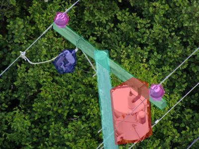
There is an industry gap for publicly available electric utility infrastructure imagery. The Electric Power Research Institute (EPRI) is filling this gap to support public and private sector AI innovation. This dataset consists of ~30,000 images of overhead Distribution infrastructure. These images have been anonymized, reviewed, and .exif image-data scrubbed. EPRI intends to label these data to support its own research activities. As these labels are created, EPRI will periodically update this dataset with those data.
Update: July 2022
- Categories:
2366 Views