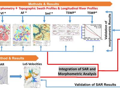
Geoscience and Remote Sensing
VEDAI: The VEDAI dataset comprises 1246 high-resolution RGB and infrared images, containing 3640 objects categorized into 8 common vehicle classes. Each image, with a resolution of 1024 × 1024 pixels, spans diverse terrains and environments. Notably, vehicles occupy only a small portion of the image pixels, making small object detection particularly challenging.
- Categories:
The field data set is collected in Hangzhou, Zhejiang Province, China. A linear array of 48 Fairfield Nodal ZLand 3C 5 Hz seismic sensors with approximately 5-m spacing was deployed to continuously record cultural noise from 10:00 am to about 02:45 pm, 24 June, 2019 (Beijing time) at a sampling frequency of 1000 Hz. The raw data includes 48 data files with the size of 201,312 kb and a file of the location information of all the receivers. Noted that the two horizontal components of sensors are oriented in the inline and crossline directions.
- Categories:
A new small aerial flame dataset, called the Aerial Fire and Smoke Essential (AFSE) dataset, is created which is comprised of screenshots from different YouTube wildfire videos as well as images from FLAME2. Two object categories are included in this dataset: smoke and fire. The collection of images is made to mostly contain pictures utilizing aerial viewpoints. It contains a total of 282 images with no augmentations and has a combination of images with only smoke, fire and smoke, and no fire nor smoke.
- Categories:
Due to climate change, the Northwesterner Gilgit Baltistan's, Ghizer district is highly susceptible to glacial lake outburst floods (GLOFs). Nearly 24 GLOFs have occurred in this area in the last ∼200 years, demonstrating the growing recurrent nature of these incidents. Taking this into account, the assessment of risks associated with GLOFs was investigated in this study. All regional glacial lakes were identified in the first phase, and changes between 2000 and 2023 were mapped using moderate-resolution satellite images (Landsat).
- Categories:
The constructed dataset comprises two representative scene types. The open-pit coal mining scenes (OCMS) include 201 original samples, which yielded 3247 standardized 224×224-pixel samples after target purification. The dataset is split 8:1:1 into training (2597 samples), validation (349 samples), and testing (301 samples). The composite coal-related scenes (CCS) include 272 original samples, which yielded 1531 standardized samples, also divided 8:1:1 into training (1223), validation (154), and testing (154).
- Categories:
RSHIP137 is a self-built remote sensing dataset of ships, consisting of 119,330 images across 137 categories. The size of each image varies, with the largest having dimensions of 182x699 and the smallest being 7x11. The distribution of categories is highly imbalanced, with the most frequent category being "Barge," which contains 31,466 images, and the least frequent category being "901-fast combat support ship," with only 15 images.
- Categories:
output mat: 60-day SR-SICFormer forecasting data
label mat: 60-day remote sensing ground truth
nan_mat: land-sea mask
maks: lat-lon mask
- Categories:
The dataset consists of Sentinel-1 SAR data sampled from areas near Shanghai, China, capturing diverse urban and natural landscapes. The polarization mode employed is VV+VH, providing both vertical-vertical and vertical-horizontal polarized signals to enhance the richness of the information. To simulate real-world conditions, gamma noise has been intentionally introduced, mimicking the noise that typically arises during SAR image sampling and processing.
- Categories:
Based on the analysis of laser characteristics, we have created a simulated dataset of near-infrared images of 1064nm laser spots. The spot collection process was carried out under natural light conditions. The divergence phenomenon during laser irradiation was excluded because the emitted 1064nm laser spots are adjustable.
- Categories: