FLAME 2: Fire detection and modeLing: Aerial Multi-spectral imagE dataset
- Citation Author(s):
-
Bryce Hopkins (Clemson University)Leo O'Neill (Northern Arizona University)Eric Rowell (Desert Research Institute)Peter Fule (Northern Arizona University)Janice Coen (National Center for Atmospheric Research)
- Submitted by:
- IS-WiN Lab
- Last updated:
- DOI:
- 10.21227/swyw-6j78
- Data Format:
Abstract
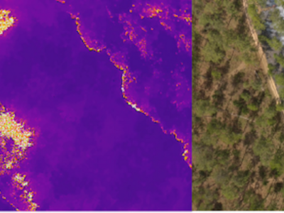
Drone based wildfire detection and modeling methods enable high-precision, real-time fire monitoring that is not provided by traditional remote fire monitoring systems, such as satellite imaging. Precise, real-time information enables rapid, effective wildfire intervention and management strategies. Drone systems’ ease of deployment, omnidirectional maneuverability, and robust sensing capabilities make them effective tools for early wildfire detection and evaluation, particularly so in environments that are inconvenient for humans and/or terrestrial vehicles. Development of emerging drone-based fire monitoring systems has been inhibited by a lack of well-annotated, high quality aerial wildfire datasets, largely as a result of UAV flight regulations for prescribed burns and wildfires. The included dataset provides a collection of side-by-side infrared and visible spectrum video pairs taken by drones during an open canopy prescribed fire in Northern Arizona in 2021. The frames have been classified by two independent classifiers with two binary classifications. The Fire label is applied when the classifiers visually observe indications of fire in either RGB or IR frame for each frame pair. The Smoke label is applied when the classifiers visually estimate that at least 50% of the RGB frame is filled with smoke. To provide additional context to the main dataset’s aerial imagery, the provided supplementary dataset includes weather information, the prescribed burn plan, a geo-referenced RGB point cloud of the preburn area, an RGB orthomosaic of the preburn area, and links to further information.
Instructions:
The FLAME 2 dataset has two main sections: the main dataset (items #1 - #10) and the supplementary dataset (items #11 - #18). The main dataset consists of raw and manipulated aerial imagery collected during a prescribed fire in an open canopy pine forest in Northern Arizona in November 2021. The main dataset contains seven raw, unlabeled RGB and IR video pairs, a set of labeled original resolution RGB/IR frame pairs, and a set of 254p x 254p RGB/IR frame pairs. Both sets of frame pairs are derived from the 7 raw video pairs. Both frame pair sets have been labeled on a frame-by-frame basis by two experts. The “Fire/NoFire” label indicates whether the experts observe fire in the RGB or IR image of each pair. The “Smoke/NoSmoke” label indicates whether the experts visually estimate that smoke fills at least 50% of the 254p x 254p RGB frame. Context for the main dataset’s aerial imagery is provided by the items of the supplementary dataset, which includes weather information, raw preburn videos, a burn plan, a geo-referenced pre-burn pointcloud, a RGB pre-burn orthomosaic, and other additional information. Each item in the FLAME 2 dataset is described in more detail below:
If the FLAME 2 dataset assists your work, please cite the introductory IEEE access paper as well as this dataset.
Introductory IEEE Access Paper Link: https://ieeexplore.ieee.org/document/9953997
DOI: 10.1109/ACCESS.2022.3222805
Main Dataset Contents:
Item #1) Raw Video Pair 1. Consists of side-by-side RGB and IR video (.mp4) captured with a Mavic 2 Enterprise Advanced dual RGB/IR camera. The 3.5 GB RGB video is 3840p x 2160p while the 322 MB IR video is 640p x 512p. Both videos are taken at 30 FPS and last 291 seconds. Unlabeled. The combined zip file is 3.81 GB.
Item #2) Raw Video Pair 2. Consists of side-by-side RGB and IR video (.mp4) captured with a Mavic 2 Enterprise Advanced dual RGB/IR camera. The 2.2 GB RGB video is 3840p x 2160p while the 199 MB IR video is 640p x 512p. Both videos are taken at 30 FPS and last 183 seconds. Unlabeled. The combined zip file is 2.39 GB.
Item #3) Raw Video Pair 3. Consists of side-by-side RGB and IR video (.mp4) captured with a Mavic 2 Enterprise Advanced dual RGB/IR camera. The 1.69 GB RGB video is 1920p x 1080p while the 446 MB IR video is 640p x 512p. Both videos are taken at 30 FPS and last 404 seconds. Unlabeled. The combined zip file is 2.13 GB.
Item #4) Raw Video Pair 4. Consists of side-by-side RGB and IR video (.mp4) captured with a Mavic 2 Enterprise Advanced dual RGB/IR camera. The 1.26 GB RGB video is 1920p x 1080p while the 333 MB IR video is 640p x 512p. Both videos are taken at 30 FPS and last 301 seconds. Unlabeled. The combined zip file is 1.59 GB.
Item #5) Raw Video Pair 5. Consists of side-by-side RGB and IR video (.mp4) captured with a Mavic 2 Enterprise Advanced dual RGB/IR camera. The 1.12 GB RGB video is 1920p x 1080p while the 297 MB IR video is 640p x 512p. Both videos are taken at 30 FPS and last 267 seconds. Unlabeled. The combined zip file is 1.41 GB.
Item #6) Raw Video Pair 6. Consists of side-by-side RGB and IR video (.mp4) captured with a Mavic 2 Enterprise Advanced dual RGB/IR camera. The 800 MB RGB video is 1920p x 1080p while the 206 MB IR video is 640p x 512p. Both videos are taken at 30 FPS and last 185 seconds. Unlabeled. The combined zip file is 0.98 GB.
Item #7) Raw Video Pair 7. Consists of side-by-side RGB and IR video (.mp4) captured with a Mavic 2 Enterprise Advanced dual RGB/IR camera. The 1.00 GB RGB video is 1920p x 1080p while the 266 MB IR video is 640p x 512p. Both videos are taken at 30 FPS and last 239 seconds. Unlabeled. The combined zip file is 1.26 GB.
Item #1-7) A zipped file including all of the seven video pairs in items #1) through #7) that is provided for a more convienient download of the video pairs. The zip file is 13.6 GB.
Item #8) Original Resolution Frame Pairs. Consists of 53,541 side-by-side RGB/IR frame pairs (.jpg) extracted from the raw video pairs in items #1 - #7. There are 13,700 3840p x 2160p RGB frames which are 58.3 GB. There are 39,751 1920p x 1080p RGB frames which are 46.6 GB. There are 53,451 640p x 512p IR frames which are 21.6 GB. The frame pairs are labeled with a “Fire/NoFire” label and a “Smoke/NoSmoke” label (see Item #10). The combined zip file is 126 GB.
Item #9) Original Resolution Frame Pairs. Consists of 53,541 side-by-side RGB/IR frame pairs (.jpg) extracted from the raw video pairs in items #1 - #7. The frames have then been scaled down to 254p x 254p and cropped such that both the RGB/IR frame possess a similar FOV and perspective. There are 53,451 RGB frames totaling 3.04 GB along with 53,451 IR frames totaling 5.30 GB. The frame pairs are labeled with a “Fire/NoFire” label and a “Smoke/NoSmoke” label (see Item #10).
Item #10) Frame Pair Labels. Consists of a 543 B text file (.txt) that outlines the “Fire/NoFire” and “Smoke/NoSmoke” labels for the frame pair sets. Includes a header with additional information on the labels.
Supplementary Dataset Contents:
Item #11) README. Text file (.txt) format of README describing supplementary dataset contents. Includes links to additional resources (not hyperlinks). 3.1 KB total.
Item #12) README. PDF file (.pdf) format of README describing supplementary dataset contents. Includes links to additional resources (with hyperlinks). 51 KB total.
Item #13) Fire Plan. Incident Action Plan (IAP) for the Blue Stem prescribed burn. The PDF (.pdf) totals 2.6 MB. Includes a rough map of the burn area.
Item #14) RGB Pointcloud. Georeferenced RGB pointcloud of preburn area, based on preburn videos (items #17 and #18). The file (.laz) is 108 MB. A mean error of 0.705 m and a resolution
of 7.6 cm/px were obtained for the pointcloud.
Item #15) RGB Orthomosaic. Image (.jpg) of RGB orthomosaic produced with preburn videos (items #17 and #18). The file is 5.4 MB.
Item #16) Weather Forecast. Includes a 6.4 MB image (.jpg) of the national weather forecast during the prescribed burn.
Item #17) Preburn Video 1. 3840p x 2160p RGB video (.mp4) of the preburn forest. The video was taken by a Zenmuse X4S. The 2.66 GB video lasts 291 seconds at 30 FPS.
Item #18) Preburn Video 2. 3840p x 2160p RGB video (.mp4) of the preburn forest. The video was taken by a Zenmuse X4S. The 1.56 GB video lasts 183 seconds at 30 FPS.
Acknowledgements:
Thanks to USDA Forest Service, and Kaibab National Forest for providing access to the prescribed fire.
Dataset Files
- #1) Video Pair 1.zip (3.81 GB)
- #1-7) All Video Pairs.zip (13.61 GB)
- #10) Frame Pair Labels.txt (543 bytes)
- #11) README.txt (3.08 KB)
- #12) README.pdf (54.31 KB)
- #13) Burn Plan.pdf (2.6 MB)
- #14) RGB Pointcloud.laz (108 MB)
- #15) RGB Orthomosaic.jpg (5.43 MB)
- #16) Weather Forecast.jpg (6.37 MB)
- #17) RGB Preburn Video 1.MP4 (2.66 GB)
- #18) RGB Preburn Video 2.MP4 (1.56 GB)
- #2) Video Pair 2.zip (2.4 GB)
- #3) Video Pair 3.zip (2.13 GB)
- #4) Video Pair 4.zip (1.59 GB)
- #5) Video Pair 5.zip (1.42 GB)
- #6) Video Pair 6.zip (1005.34 MB)
- #7) Video Pair 7.zip (1.27 GB)
- #8) Original Resolution Frame Pairs.zip (126.45 GB)
- #9) 254p Frame Pairs.zip (8.3 GB)
 22317 views


