Image Fusion

This dataset was acquired at the Radboud University Medical Center, Nijmegen, the Netherlands and enriched with landmarks by Fraunhofer MEVIS. It consists of nine datasets of consecutive sections, each containing four slides stained with H&E, CD8, CD45, Ki67, respectively.
- Categories:
 1897 Views
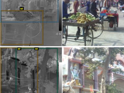
We present here an annotated thermal dataset which is linked to the dataset present in https://ieee-dataport.org/open-access/thermal-visual-paired-dataset
To our knowledge, this is the only public dataset at present, which has multi class annotation on thermal images, comprised of 5 different classes.
This database was hand annotated over a period of 130 work hours.
- Categories:
1122 Views
<p>This is the image dataset for satellite image processing which is a collection therml infrared and multispectral images .</p>
- Categories:
3481 Views
WITH the advancement in sensor technology, huge amounts of data are being collected from various satellites. Hence, the task of target-based data retrieval and acquisition has become exceedingly challenging. Existing satellites essentially scan a vast overlapping region of the Earth using various sensing techniques, like multi-spectral, hyperspectral, Synthetic Aperture Radar (SAR), video, and compressed sensing, to name a few.
- Categories:
1673 ViewsWITH the advancement in sensor technology, huge amounts of data are being collected from various satellites. Hence, the task of target-based data retrieval and acquisition has become exceedingly challenging. Existing satellites essentially scan a vast overlapping region of the Earth using various sensing techniques, like multi-spectral, hyperspectral, Synthetic Aperture Radar (SAR), video, and compressed sensing, to name a few.
- Categories:
46 Views
WITH the advancement in sensor technology, huge amounts of data are being collected from various satellites. Hence, the task of target-based data retrieval and acquisition has become exceedingly challenging. Existing satellites essentially scan a vast overlapping region of the Earth using various sensing techniques, like multi-spectral, hyperspectral, Synthetic Aperture Radar (SAR), video, and compressed sensing, to name a few.
- Categories:
463 ViewsWITH the advancement in sensor technology, huge amounts of data are being collected from various satellites. Hence, the task of target-based data retrieval and acquisition has become exceedingly challenging. Existing satellites essentially scan a vast overlapping region of the Earth using various sensing techniques, like multi-spectral, hyperspectral, Synthetic Aperture Radar (SAR), video, and compressed sensing, to name a few.
- Categories:
313 Views
With the advancement in sensor technology, huge amounts of data are being collected from various satellites. Hence, the task of target-based data retrieval and acquisition has become exceedingly challenging. Existing satellites essentially scan a vast overlapping region of the Earth using various sensing techniques, like multi-spectral, hyperspectral, Synthetic Aperture Radar (SAR), video, and compressed sensing, to name a few.
- Categories:
337 ViewsWith the advancement in sensor technology, huge amounts of data are being collected from various satellites. Hence, the task of target-based data retrieval and acquisition has become exceedingly challenging. Existing satellites essentially scan a vast overlapping region of the Earth using various sensing techniques, like multi-spectral, hyperspectral, Synthetic Aperture Radar (SAR), video, and compressed sensing, to name a few.
- Categories:
395 Views
As part of the 2018 IEEE GRSS Data Fusion Contest, the Hyperspectral Image Analysis Laboratory and the National Center for Airborne Laser Mapping (NCALM) at the University of Houston are pleased to release a unique multi-sensor optical geospatial representing challenging urban land-cover land-use classification task. The data were acquired by NCALM over the University of Houston campus and its neighborhood on February 16, 2017 between 16:31 and 18:18 GMT.
- Categories:
7913 Views