Image Processing

These simulated live cell microscopy sequences were generated by the CytoPacq web service https://cbia.fi.muni.cz/simulator [R1]. The dataset is composed of 51 2D sequences and 41 3D sequences. The 2D sequences are divided into distinct 44 training and 7 test sets. The 3D sequences are divided into distinct 34 training and 7 test sets. Each sequence contains up to 200 frames.
- Categories:
 313 Views
The dataset contains UAV imagery and fracture interpretation of rock outcrops acquired in Praia das Conchas, Cabo Frio, Rio de Janeiro, Brazil. Along with georeferenced .geotiff images, the dataset contains filtered 500 x 500 .png tiles containing only scenes with fracture data, along with .png binary masks for semantic segmentation and original georeferenced shapefile annotations. This data can be useful for segmentation and extraction of geological structures from UAV imagery, for evaluating computer vision methodologies or machine learning techniques.
- Categories:
576 Views
Datasets for image and video aesthetics
1. Video Dataset : 107 videos
This dataset has videos that can be framed into images.
Color contrast,Depth of Field[DoF],Rule of Third[RoT] attributes
that affect aesthetics can be extracted from the video datasets.
2.Slow videos and Fast videos can be assessed for motion
affecting aesthetics
- Categories:
291 Views
Please cite the following paper when using this dataset:
N. Thakur, "Twitter Big Data as a Resource for Exoskeleton Research: A Large-Scale Dataset of about 140,000 Tweets from 2017–2022 and 100 Research Questions", Journal of Analytics, Volume 1, Issue 2, 2022, pp. 72-97, DOI: https://doi.org/10.3390/analytics1020007
Abstract
- Categories:
2800 Views
In recent years, many unmanned retail stores have been introduced with the development
of computer vision, sensors and wireless technology. However, the trend has slowed due to the costs
associated with implementation. A vision-based kiosk, which is only equipped with a vision sensor, can
be a compact and affordable option. The vision-based kiosk detects a product via CNN-based object
detectors and performs instance-level classification by aggregating detections from multiple cameras.
- Categories:
546 Views
- Categories:
922 Views
We propose a novel high-resolution dataset named, “Dataset for Indian Road Scenarios (DIRS21)” for developing perception systems for advanced driver assistance systems.
- Categories:
4648 Views
Computer vision and image processing have made significant progress in many real-world applications, including environmental monitoring and protection. Recent studies have shown that computer vision and image processing can be used to quantify water turbidity, a crucial physical parameter in water quality assessment. This paper presents a procedure to determine water turbidity using deep learning methods, specifically, convolutional neural network (CNN). At first, water samples were located inside a dark cabin before digital images of the samples were captured with a smartphone camera.
- Categories:
1645 Views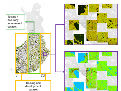
Here, a dataset used in manuscript "Wide-Area Land Cover Mapping with Sentinel-1 Imagery using Deep Learning Semantic Segmentation Models" Scepanovic et al. (https://doi.org/10.1109/JSTARS.2021.3116094) is published. The data contains preprocessed SAR backscatter digital numbers as 7000 geotiff image patches of size 512x512 (about 10 km x 10 km size) sampled from several wide-area SAR mosaics compiled from all summer Sentinel-1A images acquired over Finland in the summer of 2018.
- Categories:
712 Views
ABSTRACT
Europe is covered by distinct climatic zones which include semiarid, the Mediterranean, humid subtropical, marine,
humid continental, subarctic, and highland climates. Land use and land cover change have been well documented in the
past 200 years across Europe1where land cover grassland and cropland together make up 39%2. In recent years, the
agricultural sector has been affected by abnormal weather events. Climate change will continue to change weather
- Categories:
504 Views