Fractures in UAV Imagery for Segmentation

- Citation Author(s):
-
Vitor Lamy Mesiano Savastano (Petrobras)Davi Bortolotti Batista
- Submitted by:
- Davi Batista
- Last updated:
- DOI:
- 10.21227/5939-y446
- Data Format:
 591 views
- Categories:
- Keywords:
Abstract
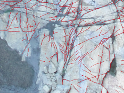
The dataset contains UAV imagery and fracture interpretation of rock outcrops acquired in Praia das Conchas, Cabo Frio, Rio de Janeiro, Brazil. Along with georeferenced .geotiff images, the dataset contains filtered 500 x 500 .png tiles containing only scenes with fracture data, along with .png binary masks for semantic segmentation and original georeferenced shapefile annotations. This data can be useful for segmentation and extraction of geological structures from UAV imagery, for evaluating computer vision methodologies or machine learning techniques.
Instructions:
The geotiff folder contains all georeferenced 500x500 tile images with all data, including all-black images, scenes of sea and vegetation. The images folder contain 500x500 .PNG images with rock outcrops containing geological structures. In the masks folder, there are .PNG binary masks for the previous images, with pixels values representing two classe: 0 for background and 1 for fractures. The shapefile folder contains the same data as mentioned masks, though as georeferenced and vectorized annotation originally interpreted by the geoscientist, to be used in GIS software.


