Geo-Sensing

Ground Penetrating Radar (GPR) has a wide range of applications such as detection of buried mines, pipes and wires. GPR has been used as a near-surface remote sensing technique, and its working principle is based on electromagnetic (EM) wave theory. Here proposed data set is meant for data driven surrogate modelling based Buried Object Characterization. The considered problem of estimating geophysical parameters of a buried object is 2D. The training and testing scenarios include B-scan images (2D data), which contain 16 pairs of A-scan (concatenated forms of A-scans).
- Categories:
 871 Views
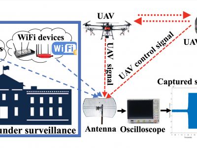
This article presents the details of the Cardinal RF (CardRF) dataset. CardRF is acquired to foster research in RF- based UAV detection and identification or RF fingerprinting. RF signals were collected from UAV controllers, UAV, Bluetooth, and Wi-Fi devices. Signals are collected at both visual line-of-sight and beyond-line-of-sight. The assumptions and procedure for the data acquisition are presented. A detailed explanation of how the data can be utilized is discussed. CardRF is over 65 GB in storage memory.
- Categories:
9713 Views
The Copernicus Sentinel-3 mission is part of the first generation of Copernicus satellites and was set out to deliver operationally high quality measurements over ocean, land and atmosphere. The European Space Agency is now studying concepts for the Next Generation Sentinel-3 Topography mission (S3NGT) mission that would launch in the 2032+ time period. In order to meet the primary objectives of the S3NGT mission requirement document a complex analysis of river and lake targets is required to size the satellite mass memory and downlink system.
- Categories:
770 Views
The Internet of Things and edge computing are fostering a future of ecosystems
hosting complex decentralized computations, deeply integrated with our very dynamic
environments. Digitalized buildings, communities of people, and cities will be the
next-generation “hardware and platform”, counting myriads of interconnected devices, on top of
which intrinsically-distributed computational processes will run and self-organize. They will
spontaneously spawn, diffuse to pertinent logical/physical regions, cooperate and compete,
- Categories:
169 Views
This dataset contains the vehicular densities from a location in Jeju-si, South Korea. The dataset considers the regions to be classified as a tracking area code (TAC) cell, over which the time-series data for multi-class vehicular densities is provided.The dataset contains the major areas/junctions from where the Jeju International Airport and Jeju Seaport traffic passes on daily. Jeju International Airport is one of the busiest airpots in the world.
- Categories:
222 Views
This dataset contains the vehicular traces from a location in Jeju-si, South Korea. The dataset contains 8,495,739 traces of vehicles. It comprises of major areas/junctions of which one is the intersection from where the Jeju International Airport and Jeju Seaport traffic passes on daily. Jeju International Airport is one of the busiest airpots in the world. Four types of vehicles were considered in the simulation of dataset, i.e., buses, trucks, passenger-cars, taxies. Each trace contains:
-
time (timestep in seconds)
- Categories:
1042 Views
<p>This is the image dataset for satellite image processing which is a collection therml infrared and multispectral images .</p>
- Categories:
3483 Views
This study presents a dataset that comprises the magnetic field, Wi-Fi, and the data from the inertial measurement unit (IMU) sensors of the smartphone including accelerometer, gyroscope, and barometer. First, the important
characteristics of both the Wi-Fi and the magnetic field that require further investigation are highlighted, and later the data are collected. The data are collected over a longer period spanning approximately five years involving five
- Categories:
721 Views
WITH the advancement in sensor technology, huge amounts of data are being collected from various satellites. Hence, the task of target-based data retrieval and acquisition has become exceedingly challenging. Existing satellites essentially scan a vast overlapping region of the Earth using various sensing techniques, like multi-spectral, hyperspectral, Synthetic Aperture Radar (SAR), video, and compressed sensing, to name a few.
- Categories:
1673 ViewsWITH the advancement in sensor technology, huge amounts of data are being collected from various satellites. Hence, the task of target-based data retrieval and acquisition has become exceedingly challenging. Existing satellites essentially scan a vast overlapping region of the Earth using various sensing techniques, like multi-spectral, hyperspectral, Synthetic Aperture Radar (SAR), video, and compressed sensing, to name a few.
- Categories:
46 Views