
Transportation

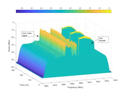
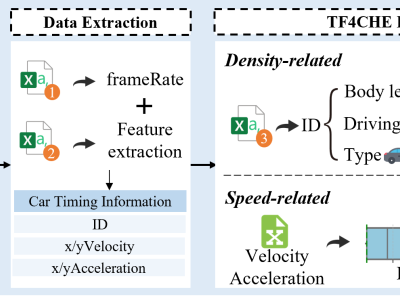
The Traffic Flow Dataset for China’s Congested Highways & Expressways (TF4CHE) is derived from AD4CHE (Aerial Dataset for China's Congested Highways & Expressways). AD4CHE collects data using unmanned aerial vehicles (UAVs) operating at an altitude of 100 meters and employs advanced calibration techniques to achieve a positioning accuracy of approximately 5 cm. It provides comprehensive vehicle metrics, including position, speed, classification, as well as unique parameters such as self-offset and yaw rate.

Categories:

This paper explores the applications of the 45 MHz U-NII-4 band in vehicle-to-everything (V2X) communication system, a technology adopted (or being adopted) by numerous countries to facilitate safety warning applications and mitigate collision risks. However, the operational efficiency of V2X systems can be undermined by intentional and unintentional interference provoked by the increasing user base in adjacent bands and potential malicious entities in the V2X operating band.

Categories:
We obtained the data by selecting the same direction on the same metro line and gathering bandwidth data every second. The bandwidth exhibits fluctuations within the range of 0 MB/s to 12 MB/s, indicating that the network status changes frequently.
Categories:

We developed IIST BCI Dataset-9, a novel EEG-based Brain-Computer Interface (BCI)
dataset to improve wheelchair control systems using Malayalam dialect variations. BCI
systems help people with motor disabilities by allowing them to control devices using brain
signals. The limited number of BCI datasets in Indian languages makes it harder for native
speakers to use these systems. To address this, we created a dataset with 15 Malayalam
words related to basic wheelchair commands like Forward, Backward, Go, Stop, Reverse,

Categories:

ITDAV-25 (Indian Thermal Dataset for Autonomous Vehicles), a thermal image dataset specifically curated to advance research in Advanced Driver Assistance Systems (ADAS), particularly for environments characterized by low visibility, night-time conditions, and inclement weather. The dataset comprises of 13,688 raw thermal images, collected without any synthetic augmentation techniques.

Categories:

The dataset is constructed using SUMO. It contains two road network datasets of different scales: a small-scale network (SR) and a larger regional network in Shenyang (SY). The dataset was constructed using the SUMO simulation platform, containing two road network datasets at different scales: a small-scale test network (SR) and a regional-level Shenyang network (SY). The SR network comprises 110 road segments, while the SY network contains 514 segments.

Categories:

Adverse driving conditions like darkness, rain, and fog present significant challenges to professional drivers as well as to computer vision algorithms in autonomous vehicles. One potential solution is to use an on-board system for real-time image translation, transforming weather-affected images into clear ones.

Categories:

This study presents a deep learning-based framework for detecting vehicle deceleration patterns using Ultra-Wideband (UWB) Channel Impulse Response (CIR) analysis. Unlike traditional GPS or IMU-based systems, which struggle in GPS-denied environments such as tunnels, the proposed method leverages UWB CIR signal variations to classify two key driving behaviors: rapid deceleration and gradual deceleration. All data were collected from real-world experiments using UWB devices installed on actual vehicles at a professional highway testing site.

Categories: