Remote Sensing

SAR-optical remote sensing couples are widely exploited for their complementarity for land-cover and crops classifications, image registration, change detections and early warning systems. Nevertheless, most of these applications are performed on flat areas and cannot be generalized to mountainous regions. Indeed, steep slopes are disturbing the range sampling which causes strong distortions in radar acquisitions - namely, foreshortening, shadows and layovers.
- Categories:
 485 Views
Recent advances in Wi-Fi sensing have ushered in a plethora of pervasive applications in home surveillance, remote healthcare, road safety, and home entertainment, among others. Most of the existing works are limited to the activity classification of a single human subject at a given time. Conversely, a more realistic scenario is to achieve simultaneous, multi-subject activity classification. The first key challenge in that context is that the number of classes grows exponentially with the number of subjects and activities.
- Categories:
924 Views
China has experienced a rapid urbanization over the past three decades, resulting in a prominent “urban core-suburban-rural” (USR) triad structure of human settlements. The USR disparities, which are related to the spatial variations of human activity intensity, have significant impacts on the spatiotemporal variations in various environmental issues such as carbon dioxide (CO2) emissions, carbon storage, water quality, etc. However, there is a lack of national-level, long-term USR dataset compared to the large number of “Urban-Rural” dual structure datasets.
- Categories:
793 Views
When considering urban growth in metropolitan areas, polycentric urban structures have been significantly observable everywhere, both in developing and developed nations. Morphological urban developments have been considered in many studies, and recently, attention has been paid to polycentric cities. Polycentricism is a collective concept that works at local, regional, and national levels. However, the development of polycentric urban spaces includes a multitude of decentralized morphologies and functional properties that have significant impacts.
- Categories:
34 Views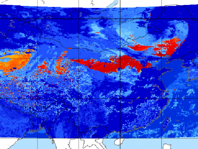
Since meteorological satellites can observe the Earth’s atmosphere from a spatial perspective at a large scale, in this paper, a dust storm database is constructed using multi-channel and dust label data from the Fengyun-4A (FY-4A) geosynchronous orbiting satellite, namely, the Large-Scale Dust Storm database based on Satellite Images and Meteorological Reanalysis data (LSDSSIMR), with a temporal resolution of 15 minutes and a spatial resolution of 4 km from March to May of each year during 2020–2022.
- Categories:
871 Views
Our large scale alpine land cover dataset consists of 229'535 very high-resolution aerial images (50cm) and digital elevation model (50cm) with land cover annotations produced by experts in photo-interpretration . The nine land cover types in our study area include bedrock, bedrock with grass, large blocks, large blocks with grass, scree, scree with grass, water area, forest and glacier. The distribution of pixels among classes presents a typical case of a long-tailed distribution with an imbalance factor, defined as the ratio of the most frequent to the rarest class, close to 1000.
- Categories:
298 Views
Dataset for validation of a new magnetic field-based wearable breathing sensor (MAG), which uses the movement of the chest wall as a surrogate measure of respiratory activity. Based on the principle of variation in magnetic field strength with the distance from the source, this system explores Hall effect sensing, paired with a permanent magnet, embedded in a chest strap.
- Categories:
532 Views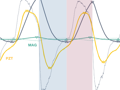
Dataset for validation of a new magnetic field-based wearable breathing sensor (MAG), which uses the movement of the chest wall as a surrogate measure of respiratory activity. Based on the principle of variation in magnetic field strength with the distance from the source, this system explores Hall effect sensing, paired with a permanent magnet, embedded in a chest strap.
- Categories:
148 Views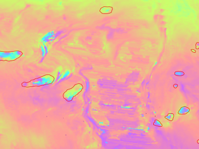
Slow moving motions are mostly tackled by using the phase information of Synthetic Aperture Radar (SAR) images through Interferometric SAR (InSAR) approaches based on machine and deep learning. Nevertheless, to the best of our knowledge, there is no dataset adapted to machine learning approaches and targeting slow ground motion detections. With this dataset, we propose a new InSAR dataset for Slow SLIding areas DEtections (ISSLIDE) with machine learning. The dataset is composed of standardly processed interferograms and manual annotations created following geomorphologist strategies.
- Categories:
1305 Views
A spectral signatures database of major crops in the East Mediterranean basin was created to support remote sensing applications specifically satellite hyperspectral and multispectral image classification. Moreover, it can be used to compute many important hyperspectral vegetation indices such as:
Atmospherically Resistant Vegetation Index (ARVI)
Modified Chlorophyll Absorption Ratio Index (MCARI)
Modified Chlorophyll Absorption Ratio Index - Improved (MCARI2)
- Categories:
802 Views