Remote Sensing

The utilization of unmanned aerial vehicle (UAV) remote sensing allows for fast and effective soil moisture content (SMC) monitoring. Scale conversion can obtain remote sensing images at multiple resolutions and offer the possibility of improving the estimation accuracy of SMC, which is significant for precision agriculture. To explore the effect of upscaling conversion on SMC monitoring with UAV remote sensing, multispectral images and SMC data at different soil depths were acquired.
- Categories:
 322 Views
QiandaoEar22 is a high-quality noise dataset designed for identifying specific ships among multiple underwater acoustic targets using ship-radiated noise. This dataset includes 9 hours and 28 minutes of real-world ship-radiated noise data and 21 hours and 58 minutes of background noise data.
- Categories:
994 Views
As an artificial structure, tailings ponds exhibit regular geometric shapes and relatively straight dams in HRRSIs. Because the typical tailings dam is composed of an initial dam and successive accumulation dams, the tailings dam structure presents obvious linear stripe characteristics. The initial dam, constructed using sand, gravel, or concrete, has a bright color, while the color of the accumulation dam varies based on factors such as particle size, soil coverage, and vegetation restoration.
- Categories:
89 Views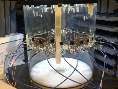
With the goal of improving machine learning approaches in inverse scattering, we provide an experimental data set collected with a 2D near-field microwave imaging system. Machine learning approaches often train solely on synthetic data, and one of the reasons for this is that no experimentally-derived public data set exists. The imaging system consists of 24 antennas surrounding the imaging region, connected via a switch to a vector network analyzer. The data set contains over 1000 full Scattering parameter scans of five targets at numerous positions from 3-5 GHz.
- Categories:
695 Views
The results are based on the measurements conducted on small drones and a bionic bird using a 60 GHz millimeter wave radar, analyzing their micro-Doppler characteristics in both time and frequency domain. The results are presented in .pkl format. The more detailed description of the data and how the authors processed it will be updated soon.
- Categories:
1601 Views
We employed Hexacopter unmanned aerial vehicle (UAV) equipped with the SPECIM FX17E hyperspectral camera to implement ultra-low-altitude flight aerial photography missions with atmospheric correction processing. We collected three hyperspectral images and combined them into three data pairs, which exhibit varying degrees of spectral shift. Among them, a hyperspectral image including six types of ground objects was collected in Changsha at 4:00 pm on September 27, 2021, with sunny weather and a flight altitude of 30m, named CSSunny.
- Categories:
151 Views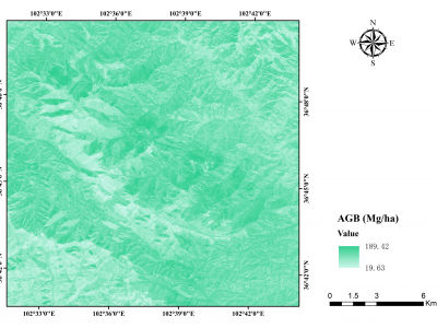
Aboveground biomass (AGB) is a vital indicator for studying the carbon sink in forest ecosystems. Semi-arid forests harbor substantial carbon storage but received little attention as high spatial-temporal heterogeneity. This study assessed the performance of different data sources (annual monthly time-series radar: Sentinel-1 (S1), annual monthly time-series optical: Sentinel-2 (S2), and single-temporal airborne LiDAR) and seven prediction approaches to map AGB in the semi-arid forests at the border between Gansu and Qinghai provinces in China.
- Categories:
131 Views
Accurately defining urban entity boundaries is crucial for analyzing urban expansion trends, understanding the impacts of urbanization on the environment, and planning and achieving sustainable urban development. In recent years, multiple global urban boundary products have emerged. However, cities’ definitions, formation processes, and morphology vary significantly across countries, making it particularly challenging to use a uniform method to delineate urban boundaries.
- Categories:
11 Views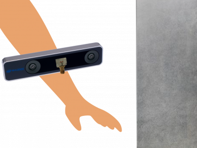
The performance of a novel ultra-compact Artificial Magnetic Conductor (AMC)-backed Twin Arrow antenna, operative in the 24 GHz frequency band, have been test for an electronic travel aid (ETA) system. Synthetic Aperture Radar (SAR) techniques for high-resolution electromagnetic imaging have been implemented by taking advantage of the natura movement of the user’s body. Experimental measurements for electronic travel aid purposes were conducted by generating electromagnetic images of the surrounding environment. The antenna is moved by means of simple arm swings.
- Categories:
174 Views
The effect of phase changes along the antenna radiation pattern beamwidth and bandwidth on synthetic aperture radar (SAR) imaging is evaluated by means of electromagnetic simulations. Electromagnetic images have been obtained in order to characterize the effect of the non-uniform phase of the antenna radiation pattern on this type of measurements. Three different situations have been analyzed: i) phase variations across the angular range, ii) nonlinear phase shift across the working frequency band and iii) antenna phase center shift across the bandwidth.
- Categories:
537 Views