Remote Sensing
Radio Frequency (RF) signals transmitted by Global Navigation Satellite Systems (GNSS) are exploited as signals of opportunity in many scientific activities, ranging from sensing waterways and humidity of the terrain to the monitoring of the ionosphere. The latter can be pursued by processing the GNSS signals through dedicated ground-based monitoring equipment, such as the GNSS Ionospheric Scintillation and Total Electron Content Monitoring (GISTM) receivers.
- Categories:
 204 Views
SWAN is a large-scale outdoor point cloud semantic segmentation, instance segmentation and object detection dataset. The dataset is targeted explicitly at the challenging urban environment, which aligns well with the needs of the intelligent transportation systems. The data is collected in the Central Business District (CBD) of Perth city in Australia, covering nearly 150km. It additionally used specialized equipment (portable trolley) to capture scenes of no-through roads and narrow streets.
- Categories:
652 Views
SWAN is a Large-Scale Outdoor Point Cloud semantic segmentation dataset . The dataset is targeted explicitly at the challenging urban environment, which aligns well with the needs of the intelligent transportation systems. The data is collected in the Central Business District (CBD) of Perth city in Australia, covering nearly 150km. It additionally used specialized equipment (portable trolley) to capture scenes of no-through roads and narrow streets.
- Categories:
119 Views
This data will be used for discontinuity identification and analysis, which contains three main sets of discontinuities with yields of 281.1°/82.0°, 114.0°/80.2° and 359.0°/81.6°.
- Categories:
55 Views
研究区域为 大红山铁矿,位于中国云南省玉溪市。 矿区海拔600米-1850米,属于侵蚀 和剥蚀山地地形,深切口,大起伏和 沟壑和山谷网络。矿井主体为裸露岩石 周围植被覆盖。主要岩性是变质熔岩, 辉长岩、辉长岩和白云石方钠石。
- Categories:
19 Views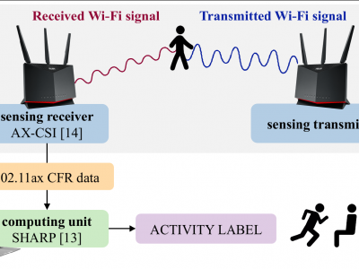
The dataset includes channel frequency response (CFR) data collected through an IEEE 802.11ax device for human activity recognition. This is the first dataset for Wi-Fi sensing with the IEEE 802.11ax standard which is the most updated Wi-Fi version available in commercial devices. The dataset has been collected within a single environment considering a single person as the purpose of the study was to evaluate the impact of communication parameters on the performance of sensing algorithms.
- Categories:
3128 ViewsBistatic MIMO Radar Sensing
This dataset includes the synthetic aperture measurement data and code accompanying the publication "Bistatic MIMO Radar Sensing of Specularly Reflecting Surfaces for Wireless Power Transfer" [1].
Description:
- Categories:
489 Views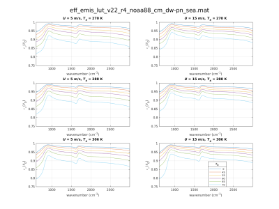
Thermal infrared (IR) environmental satellite data assimilation and remote sensing of the surface and lower troposphere depend on accurate specification of the spectral surface emissivity within clear-sky forward calculations. Over ocean surfaces, accurate modeling of surface-leaving radiances over the sensor scanning swaths is complicated by a quasi-specular bidirectional reflectance distribution function (BRDF).
- Categories:
200 Views
Detection of impact craters on the surface of Mars is a critical component in the study of Martian geomorphology and the evolution of the planet. As one of the most distinguishable geomorphic units on the Martian surface, accurate determination of the boundaries of impact craters provides valuable information in mapping and research efforts. The topography on Mars is more complex than that of the moon, making detection of real impact crater boundaries a challenging task.
- Categories:
22 Views
We propose an algorithm based on linear prediction that can perform both the lossless and near-lossless compression of RF signals. The proposed algorithm is coupled with two signal detection methods to determine the presence of relevant signals and apply varying levels of loss as needed. The first method uses spectrum sensing techniques, while the second one takes advantage of the error computed in each iteration of the Levinson-Durbin algorithm. These algorithms have been integrated as a new pre-processing stage into FAPEC, a data compressor first designed for space missions.
- Categories:
557 Views