swissALPS: a Dataset for Imbalanced Land Cover Mapping in Alpine Regions
- Citation Author(s):
-
Valérie Zermatten
 (Ecole Polytechnique Federale de Lausanne (EPFL)))
- Submitted by:
- Valerie Zermatten
- Last updated:
- DOI:
- 10.21227/n61c-k282
- Data Format:
- Links:
 305 views
- Categories:
- Keywords:
Abstract
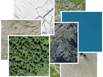
Our large scale alpine land cover dataset consists of 229'535 very high-resolution aerial images (50cm) and digital elevation model (50cm) with land cover annotations produced by experts in photo-interpretration . The nine land cover types in our study area include bedrock, bedrock with grass, large blocks, large blocks with grass, scree, scree with grass, water area, forest and glacier. The distribution of pixels among classes presents a typical case of a long-tailed distribution with an imbalance factor, defined as the ratio of the most frequent to the rarest class, close to 1000. The data are taken from the Federal Office of Topography - swisstopo
Instructions:
Use unzip to decrompress the archive.
Funding Agency
Federal Office of Topography - swisstopo