Geoscience and Remote Sensing

When considering urban growth in metropolitan areas, polycentric urban structures have been significantly observable everywhere, both in developing and developed nations. Morphological urban developments have been considered in many studies, and recently, attention has been paid to polycentric cities. Polycentricism is a collective concept that works at local, regional, and national levels. However, the development of polycentric urban spaces includes a multitude of decentralized morphologies and functional properties that have significant impacts.
- Categories:
 33 Views
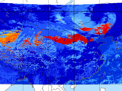
Since meteorological satellites can observe the Earth’s atmosphere from a spatial perspective at a large scale, in this paper, a dust storm database is constructed using multi-channel and dust label data from the Fengyun-4A (FY-4A) geosynchronous orbiting satellite, namely, the Large-Scale Dust Storm database based on Satellite Images and Meteorological Reanalysis data (LSDSSIMR), with a temporal resolution of 15 minutes and a spatial resolution of 4 km from March to May of each year during 2020–2022.
- Categories:
 819 Views
Adverse climatic events like heat stress, floods, unseasonal rainfall, and droughts frequently hinder crop productivity. Long-term crop yield data plays a crucial role in food security planning. This study presents historical wheat yield data at the satellite pixel level from 2001 to 2019 in Uttar Pradesh, India. We use various satellite indicators to develop wheat yield models, including the normalized difference vegetation index and gridded weather data, such as precipitation, temperature, and evapotranspiration.
- Categories:
 978 Views
Mapping millions of buried landmines rapidly and removing them cost-effectively is supremely important to avoid their potential risks and ease this labour-intensive task. Deploying uninhabited vehicles equipped with multiple remote sensing modalities seems to be an ideal option for performing this task in a non-invasive fashion. This report provides researchers with vision-based remote sensing imagery datasets obtained from a real landmine field in Croatia that incorporated an autonomous uninhabited aerial vehicle (UAV), the so-called LMUAV.
- Categories:
 1370 Views
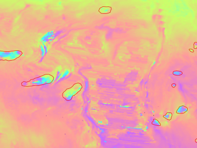
Slow moving motions are mostly tackled by using the phase information of Synthetic Aperture Radar (SAR) images through Interferometric SAR (InSAR) approaches based on machine and deep learning. Nevertheless, to the best of our knowledge, there is no dataset adapted to machine learning approaches and targeting slow ground motion detections. With this dataset, we propose a new InSAR dataset for Slow SLIding areas DEtections (ISSLIDE) with machine learning. The dataset is composed of standardly processed interferograms and manual annotations created following geomorphologist strategies.
- Categories:
 1242 Views
Indian Pines
This scene was gathered by AVIRIS sensor over the Indian Pines test site in North-western Indiana and consists of 145\times145 pixels and 224 spectral reflectance bands in the wavelength range 0.4–2.5 10^(-6) meters. This scene is a subset of a larger one.
Salinas
This scene was collected by the 224-band AVIRIS sensor over Salinas Valley, California, and is characterized by high spatial resolution (3.7-meter pixels). The area covered comprises 512 lines by 217 samples.
- Categories:
 208 Views
We used Sentinel-2 images to create the dataset In order to estimate sequestered carbon in the above-ground forest Biomass. Moreover, fieldwork was completed to gather related forest biomass volume. The clipped image has a size of 1115 × 955 pixels and consists of bands 3, 4, and 8, which correspond to green, red, and near-infrared.
- Categories:
 1101 Views
The Sentinel-2 L2A multispectral data cubes include two regions of interest (roi1 and roi2) each of them containing 92 scenes across Switzerland within T32TLT, between 2018 and 2022, all band at 10m resolution These areas of interest show a diverse landscape, including regions covered by forests that have undergone changes, agriculture and urban areas.
- Categories:
 1983 Views
Progress toward the use of S-band SoOp in sea surface remote sensing was demonstrated in a 2012-2013 experiment based at the Harvest Oil Platform located at 34.469° N and 120.682° W, roughly 11 km from Point Conception, Santa Barbara, CA. Satellite transmissions from the XM-radio service were observed, using one channel each from the “Rhythm” (located above 85°W) and the “Blues” (115°W) satellites. Each downlink channel had a bandwidth of 1.886 MHz with a symbol rate of 1.64 Msps in Quadrature Phase Shift Key (QPSK) modulation.
- Categories:
 127 Views
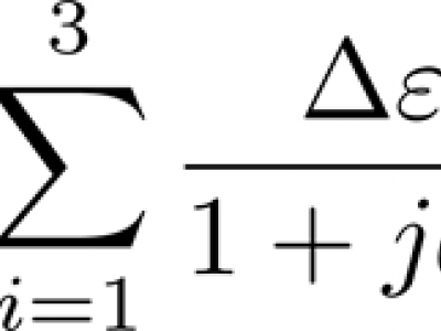
The dataset contains fitted three-pole Debye dielectric model parameters of 567 soil spectra. Three soils of loamy sand, sandy loam, and silt loam textures were tested. Of each soil, 20 samples of various water contents were prepared with the use of distilled water and potassium chloride solutions, 5 samples for each liquid. Air-dry samples were also prepared. Dielectric spectra were obtained with the use of a six-channel coaxial-transmission-line cell system at 9 controlled temperature steps from 0.5 to 40°C in the 0.02 – 3 GHz frequency range.
- Categories:
 228 Views


