Geoscience and Remote Sensing

LSD4WSD: Learning SAR Dataset for Wet Snow Detection.
The dataset can be found at : https://zenodo.org/record/8111485
- Categories:
 182 Views
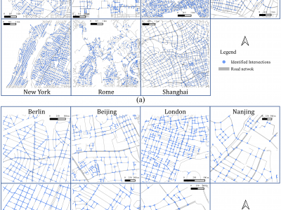
We propose a road intersection identification method based on spatial constraint relationships of vector data. To evaluate its wide applicability, OpenStreetMap (OSM) data from seven cities–Berlin, Beijing, London, Nanjing, New York City, Rome, and Shanghai–were employed to identify road intersections of these cities.
- Categories:
186 Views
Gorakhpur is a city located in the north-eastern region of
Uttar Pradesh state of India. It is a sub-part of Purvanchal
region of Uttar Pradesh and Bihar. In the south-western
part, Gorakhpur periphery spreads along Rapti river. In
the north-western region, Gorakhpur shares its periphery
with Chillua Tal. In the southern part, Ramgarh Tal with a
perimeter of 18 km is located.
Water Bodies:
+ Ramgarh Tal is a historically important heritage site and
is also a tourist attraction; spread over 700 hectares of
- Categories:
325 Views
India is a sub-continent that stretches from Ladakh in
the North to Kanyakumari in the South and from
Gujrat in the West to Arunachal Pradesh, Nagaland
and Manipur in the East. India is currently the
seventh largest country by land covering an area of
approximately 32,87,263 kms.
India's Space Strengths:
India is the fourth country in the world to have
destroyed a satellite of its own. India built the
record-breaking space capability of launching 104
satellites on a single Polar Satellite Launch Vehicle
- Categories:
101 Views
Most of the current smoke detection techniques are developed using CCTV images. To identify the wildfire early, it can be useful to deploy satellite imagery and develop models that can recognize smoke in forest areas. However, very few labelled satellite image datasets are available to build the wildfire smoke detection model. In order to find a solution to this problem, a dataset consisting 23, 644 satellite images was gathered. The dataset is divided into four categories: smoke, smoke with fog, non-smoke, and non-smoke with fog.
- Categories:
66 Views
Radio frequency interference (RFI) is a problem in microwave remote sensing even for sensors operating in the protected band at 1.4 GHz (L-band). Unfortunately, little is known about the sources of the interference, which complicates the design of systems to deal with it. The SMAP radiometer is unique in that it comprises an array of tools to detect RFI, including spectral information and kurtosis in addition to the more conventional time-domain thresholding. This data set contains examples used in an investigation to determine if the kurtosis (K) can be combined with the information abo
- Categories:
148 Views
This experiment was implemented to collect infrared images of the coal and gangue samples at the temperature of 323.15 K. Additionally, it showed that distinguishing between coal and gangue samples is feasible, although the area, thickness, and surface conditions were changed at a constant temperature during the process of capturing the infrared images. The coal and gangue were randomly collected from the same mine. The random samples had different weights, shapes, areas, thicknesses, and surface conations.
- Categories:
824 Views
Radial basis function (RBF) is a basis function suitable for scattered data interpolation and high dimensional function interpolation, wherein the independent shape parameters have a direct impact on the accuracy of calculation results. Research in this field is mostly concerned with the shape parameter selection strategy based on the premise of global distribution or block regional distribution. In this paper, a shape parameter selection strategy is proposed, which is used for the local RBF collocation method (LRBF) for solving partial differential equations.
- Categories:
70 Views
This dataset contains 6 raw ground-penetrating radar (GPR) profiles (#9, #10, #11, #14, #25, #30) collected at 4 locations in the Wahiba Sands dune field of Oman in May of 2014. The survey was performed to assess the detectability of the water table within the first 100 meters in hyper-arid sandy formations by VHF sounding radar. Profiles #9-10-11 are three parts of the same track ascending a ~36-m tall dune, and used to assess the maximum GPR penetration depth at which the water table is still detectable.
- Categories:
1239 Views
Algorithm for automating conceptual urban planning work
- Categories:
38 Views