Geoscience and Remote Sensing

Influence of PET bottle mattress in fly ash fill following methodology were studied experimentally and analytically. Positive behaviour were observed interms of load- settlement.
- Categories:
 69 Views
The lack of quality label data is considered one of the main bottlenecks for training machine and deep learning models. Weakly supervised learning using incomplete, coarse, or inaccurate data is an alternative strategy to overcome the scarcity of training data. We trained a U-Net model for segmenting Buildings’ footprints from a high-resolution digital elevation model, using existing label data from the open-access Microsoft building footprints data set.
- Categories:
235 Views
Single band homogeneous and heterogenoues dataset for change detection. The dataset includes different type of sensors an variety of cases sucha as floods, contructions, fire, ice-melting and so on.
Here you will find a demo of the work in one dataset. To acces to the full dataset please follow the github link.
- Categories:
509 Views
This is a collection of images.
- Categories:
133 Views


Radar data and Pluviometric data for Sardinia (Italy)
- Categories:
469 Views
The dataset contains UAV imagery and fracture interpretation of rock outcrops acquired in Praia das Conchas, Cabo Frio, Rio de Janeiro, Brazil. Along with georeferenced .geotiff images, the dataset contains filtered 500 x 500 .png tiles containing only scenes with fracture data, along with .png binary masks for semantic segmentation and original georeferenced shapefile annotations. This data can be useful for segmentation and extraction of geological structures from UAV imagery, for evaluating computer vision methodologies or machine learning techniques.
- Categories:
543 Views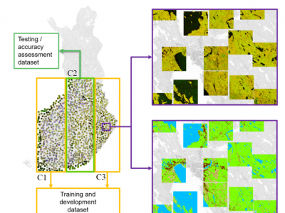
Here, a dataset used in manuscript "Wide-Area Land Cover Mapping with Sentinel-1 Imagery using Deep Learning Semantic Segmentation Models" Scepanovic et al. (https://doi.org/10.1109/JSTARS.2021.3116094) is published. The data contains preprocessed SAR backscatter digital numbers as 7000 geotiff image patches of size 512x512 (about 10 km x 10 km size) sampled from several wide-area SAR mosaics compiled from all summer Sentinel-1A images acquired over Finland in the summer of 2018.
- Categories:
651 Views