
Computer Vision

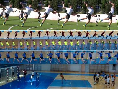
The dataset consists of 751 videos, each containing the performance one of the handball actions out of 7 categories (passing, shooting, jump-shot, dribbling, running, crossing, defence). The videos were manually extracted from longer videos recorded in handball practice sessions. 

The scenes were shot with stationary GoPro cameras that were mounted on the left or right side of the playground, from different angles. The videos were recorded in at least full HD (1920 × 1080) resolution at 30 or more frames per second. 

Categories:

Of late, efforts are underway to build computer-assisted diagnostic tools for cancer diagnosis via image processing. Such computer-assisted tools require capturing of images, stain color normalization of images, segmentation of cells of interest, and classification to count malignant versus healthy cells. This dataset is positioned towards robust segmentation of cells which is the first stage to build such a tool for plasma cell cancer, namely, Multiple Myeloma (MM), which is a type of blood cancer. The images are provided after stain color normalization.

Categories:

A fundamental building block of any computer-assisted interventions (CAI) is the ability to automatically understand what the surgeons are performing throughout the surgery. In other words, recognizing the surgical activities being performed or the tools being used by the surgeon can be deemed as an essential steps toward CAI. The main motivation for these tasks is to design efficient solutions for surgical workflow analysis. The CATARACTS dataset was proposed in this context. This dataset consists of 50 cataract surgery.

Categories:

WITH the advancement in sensor technology, huge amounts of data are being collected from various satellites. Hence, the task of target-based data retrieval and acquisition has become exceedingly challenging. Existing satellites essentially scan a vast overlapping region of the Earth using various sensing techniques, like multi-spectral, hyperspectral, Synthetic Aperture Radar (SAR), video, and compressed sensing, to name a few.

Categories:

With the advancement in sensor technology, huge amounts of data are being collected from various satellites. Hence, the task of target-based data retrieval and acquisition has become exceedingly challenging. Existing satellites essentially scan a vast overlapping region of the Earth using various sensing techniques, like multi-spectral, hyperspectral, Synthetic Aperture Radar (SAR), video, and compressed sensing, to name a few.

Categories: