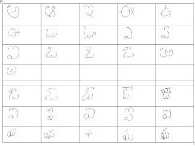
Computer Vision
Recently, self-driving vehicles have been introduced with several automated features including lane-keep assistance, queuing assistance in traffic-jam, parking assistance and crash avoidance. These self-driving vehicles and intelligent visual traffic surveillance systems mainly depend on cameras and sensors fusion systems.
- Categories:
We establish a new large-scale benchmark that contains 30 ground-truth images and 900 synthetic underwater images of the same scene, called synthetic underwater image dataset (SUID). The proposed SUID creates possibility for a full-reference evaluation of existing technologies for underwater image enhancement and restoration.
- Categories:
The dataset comprises of image file s of size 20 x 20 pixels for various types of metals and non-metal.The data collected has been augmented, scaled and modified to represent a number a training set dataset.It can be used to detect and identify object type based on material type in the image.In this process both training data set and test data set can be generated from these image files.
- Categories:
This dataset was created from all Landsat-8 images from South America in the year 2018. More than 31 thousand images were processed (15 TB of data), and approximately on half of them active fire pixels were found. The Landsat-8 sensor has 30 meters of spatial resolution (1 panchromatic band of 15m), 16 bits of radiometric resolution and 16 days of temporal resolution (revisit). The images in our dataset are in TIFF (geotiff) format with 10 bands (excluding the 15m panchromatic band).
- Categories:
This dataset extends the Urban Semantic 3D (US3D) dataset developed and first released for the 2019 IEEE GRSS Data Fusion Contest (DFC19). We provide additional geographic tiles to supplement the DFC19 training data and also new data for each tile to enable training and validation of models to predict geocentric pose, defined as an object's height above ground and orientation with respect to gravity. We also add to the DFC19 data from Jacksonville, Florida and Omaha, Nebraska with new geographic tiles from Atlanta, Georgia.
- Categories:
Cautionary traffic signs are of immense significance to traffic safety. In this study, a robust and optimal real-time approach to recognize the Indian Cautionary Traffic Signs(ICTS) is proposed. ICTS are all triangles with a white backdrop, a red border, and a black pattern. A dataset of 34,000 real-time images has been acquired under various environmental conditions and categorized into 40 distinct classes. Pre-processing techniques are used to transform RGB images to Gray-scale images and enhance contrast in images for superior performance.
- Categories:
Solving the external perception problem for autonomous vehicles and driver-assistance systems requires accurate and robust driving scene perception in both regularly-occurring driving scenarios (termed “common cases”) and rare outlier driving scenarios (termed “edge cases”). In order to develop and evaluate driving scene perception models at scale, and more importantly, covering potential edge cases from the real world, we take advantage of the MIT-AVT Clustered Driving Scene Dataset and build a subset for the semantic scene segmentation task.
- Categories:
Semantic scene segmentation has primarily been addressed by forming representations of single images both with supervised and unsupervised methods. The problem of semantic segmentation in dynamic scenes has begun to recently receive attention with video object segmentation approaches. What is not known is how much extra information the temporal dynamics of the visual scene carries that is complimentary to the information available in the individual frames of the video.
- Categories: