Thermal to Far Infrared (TIR-FIR) Sea-Surface Effective-Emissivity (IRSSE) Model Version 2
- Citation Author(s):
-
Nicholas Nalli
 (NOAA/NESDIS/STAR)
James Jung (CIMSS, UW-Madison)Robert Knuteson (SSEC, UW-Madison)Jonathan Gero (SSEC, UW-Madison)Cheng Dang (UCAR, JCSDA)Benjamin Johnson (UCAR, JCSDA)Lihang Zhou (NOAA/NESDIS/JPSS)
(NOAA/NESDIS/STAR)
James Jung (CIMSS, UW-Madison)Robert Knuteson (SSEC, UW-Madison)Jonathan Gero (SSEC, UW-Madison)Cheng Dang (UCAR, JCSDA)Benjamin Johnson (UCAR, JCSDA)Lihang Zhou (NOAA/NESDIS/JPSS) - Submitted by:
- Nicholas Nalli
- Last updated:
- DOI:
- 10.1109/TGRS.2023.3248490
- Data Format:
- Research Article Link:
 202 views
- Categories:
- Keywords:
Abstract
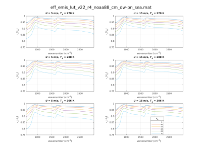
Thermal infrared (IR) environmental satellite data assimilation and remote sensing of the surface and lower troposphere depend on accurate specification of the spectral surface emissivity within clear-sky forward calculations. Over ocean surfaces, accurate modeling of surface-leaving radiances over the sensor scanning swaths is complicated by a quasi-specular bidirectional reflectance distribution function (BRDF). Recent findings at the Joint Center for Satellite Data Assimilation (JCSDA) have also revealed significant zonally varying systematic biases (≈|0.5| K) on a global scale over cold ocean waters, these the result of temperature dependence in the thermal IR optical constants. This paper proposes practical solutions to these problems by modeling thermal IR “effective emissivity” in a manner that accounts for both surface emission and quasi-specular reflectance, along with temperature dependence, while meeting the latency and computational constraints of operational global data assimilation and retrieval systems. We overview the theoretical basis of the model and validate it against ship-based Marine Atmospheric Emitted Radiance Interferometer (MAERI) spectra obtained from cold and warm water ocean campaigns.
Instructions:
See README file.