Probing Shallow Aquifers in Hyper-Arid Dune Fields Using VHF Sounding Radar: Raw ground-penetrating radar (GPR) data
- Citation Author(s):
-
Essam Heggy
([1] Department of Electrical and Computer Engineering, University of Southern California, Los Angeles, CA, USA; [2] NASA Jet Propulsion Laboratory, California Institute of Technology, Pasadena, CA, USA)
Jonathan C.L. Normand(Department of Electrical and Computer Engineering, University of Southern California, Los Angeles, CA, USA)
Elizabeth M. Palmer(Department of Electrical and Computer Engineering, University of Southern California, Los Angeles, CA, USA)
Giovanni Scabbia(Department of Electrical and Computer Engineering, University of Southern California, Los Angeles, CA, USA)
Ali K.S. Al-Maktoumi(Department of Soils, Water, and Agriculture Engineering, College of Agricultural and Marine Sciences, Sultan Qaboos University, Muscat, Oman)
Annamaria Mazzoni(Department of Electrical and Computer Engineering, University of Southern California, Los Angeles, CA, USA)
J. Lee Blanton (Metric Systems Corporation, Carlsbad, CA, USA)Sophie J.N. Schaefer (Department of Computer Science, Columbia University, New York, NY, USA) - Submitted by:
- Essam Heggy
- Last updated:
- DOI:
- 10.21227/ckx7-0s88
- Data Format:
- Research Article Link:
 1520 views
- Categories:
- Keywords:
Abstract
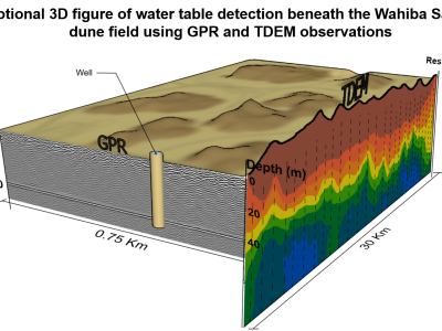
This dataset contains 6 raw ground-penetrating radar (GPR) profiles (#9, #10, #11, #14, #25, #30) collected at 4 locations in the Wahiba Sands dune field of Oman in May of 2014. The survey was performed to assess the detectability of the water table within the first 100 meters in hyper-arid sandy formations by VHF sounding radar. Profiles #9-10-11 are three parts of the same track ascending a ~36-m tall dune, and used to assess the maximum GPR penetration depth at which the water table is still detectable. Profiles #25 and #30 were acquired in the low-lying interdunal space running north-to-south where the water table is ~30 to 40 m deep, and were used to quantify dielectric and scattering losses in the desiccated medium overlying the water table. Profile #14 was acquired to validate the occurrence of shallow (~2 meter deep) buried paleochannels identified from satellite radar backscatter scenes of the Wahiba Sands.
The detailed processing, analyses and interpretations of these GPR profiles, in addition to their implications for airborne VHF sounding radar observations of shallow aquifers in hyper-arid sandy formations, are provided in Heggy et al. (2023, In Press): "Probing Shallow Aquifers in Hyper-Arid Dune Fields Using VHF Sounding Radar," IEEE Transactions on Geoscience and Remote Sensing, doi:10.1109/TGRS.2023.3306286.
Instructions:
A bistatic pair of Radarteam SubEcho SE-70 VHF antennas (80 MHz ground-coupled center frequency for a dielectric constant of 9) was used in air-launched continuous recording mode with a GSSI SIR-30 GPR system for INTERDUNE_GPR_PROFILE_30.
A bistatic pair of Radarteam SubEcho SE-40 VHF antennas (52 MHz ground-coupled center frequency for a dielectric constant of 9) was used with a GSSI SIR-30 GPR system in continuous recording mode for INTERDUNE_GPR_PROFILE_25, and in ground-coupled step mode with 1-meter spacing for a profile split into three files: DUNE_GPR_PROFILE_09, DUNE_GPR_PROFILE_10 and DUNE_GPR_PROFILE_11.
A MALA X3M GPR unit was used with a monostatic 500-MHz shielded antenna was used in continuous mode with the aid of a survey wheel encoder for PALEOCHANNEL_PROFILE_14.
GPR data products are 2D images (radargrams) showing received signal amplitude as a function of profile distance (horizontal direction) and two-way travel time through the subsurface (vertical direction). GPR radargrams acquired with the GSSI GPR system have the file extensions *.dzt, *.dzw, and sometimes *.dzx. GPR files produced with the MALA GPR system have the extensions *.rd3, *.rad, and *.mrk. The authors used the software tool ReflexW (https://www.sandmeier-geo.de/reflexw.html) for visualizing and processing radargrams. Free open source software is also available for GPR radargram viewing and/or processing, such as RGPR by Huber & Hans (2018) (doi.org/10.1109/ICGPR.2018.8441658) at https://emanuelhuber.github.io/RGPR/ .
Detailed interpretation and processing of GPR profiles in this dataset are available in: Heggy et al. (2023), "Probing Shallow Aquifers in Hyper-Arid Dune Fields Using VHF Sounding Radar", IEEE Transactions on Geoscience and Remote Sensing, doi:10.1109/TGRS.2023.3306286.




In reply to would Like to use the data to by Mohammad Asefi
Good job bro