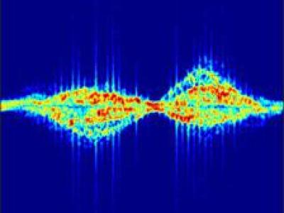
We design a solution to achieve coordinated localization between two unmanned aerial vehicles (UAVs) using radio and camera perception. We achieve the localization between the UAVs in the context of solving the problem of UAV Global Positioning System (GPS) failure or its unavailability. Our approach allows one UAV with a functional GPS unit to coordinate the localization of another UAV with a compromised or missing GPS system. Our solution for localization uses a sensor fusion and coordinated wireless communication approach.
- Categories:
There is an industry gap for publicly available electric utility infrastructure imagery. The Electric Power Research Institute (EPRI) is filling this gap to support public and private sector AI innovation. This dataset consists of ~30,000 images of overhead Distribution infrastructure. These images have been anonymized, reviewed, and .exif image-data scrubbed. These images are unlabeled and do not contain annotations. EPRI intends to label these data to support its own research activities. As these labels are created, EPRI will periodically update this dataset with those data.
These images are not labeled or annotated. However, as these images are labeled, EPRI will update this dataset periodically. If you have annotations you'd like to contribute, please send them, with a description of your labeling approach, to ai@epri.com.
Also, if you see anything in the imagery that looks concerning, please send the image and image number ai@epri.com
- Categories:
The Dasha River dataset was collected by a USV sailing along the Dasha River in Shenzhen, China. Visual images in the dataset were extracted from two videos taken from a USV perspective, with a resolution of 1920×1080 pixels. Totally 360 images were obtained after screening, and all labels were manually annotated.
- Categories:
A new generation of computer vision, namely event-based or neuromorphic vision, provides a new paradigm for capturing visual data and the way such data is processed. Event-based vision is a state-of-art technology of robot vision. It is particularly promising for use in both mobile robots and drones for visual navigation tasks. Due to a highly novel type of visual sensors used in event-based vision, only a few datasets aimed at visual navigation tasks are publicly available.
The dataset includes the following sequences:
01_winter_forest
– Daytime, No wind, Clear weather, Snowy scenery, Closed loop, Forest trail02_winter_forest
- Daytime, No wind, Clear weather, Snowy scenery, Closed loop, Forest trail03_winter_parking_lot
- Daytime, No wind, Clear weather, Snowy scenery, Closed loop, Asphalt road04_winter_bush_rows
- Daytime, No wind, Snowy scenery, Closed loop, Shrubland05_winter_bush_rows
- Daytime, No wind, Snowy scenery, Closed loop, Shrubland06_winter_greenhouse_complex
- Daytime, No wind, Snowy scenery, Closed loop, Cattle farm feed table07_winter_greenhouse_complex
- Daytime, No wind, Snowy scenery, Closed loop, Cattle farm feed table08_winter_orchard
- Daytime, No wind, Snowy scenery, Closed loop, Orchard09_winter_orchard
- Daytime, No wind, Snowy scenery, Closed loop, Orchard10_winter_farm
- Daytime, No wind, Snowy scenery, Closed loop, Cattle farm feed table11_winter_farm
- Daytime, No wind, Snowy scenery, Closed loop, Cattle farm feed table12_summer_bush_rows
- Daytime, Mild wind, Closed loop, Shrubland13_summer_bush_rows
- Daytime, Mild wind, Closed loop, Shrubland14_summer_farm
- Daytime, Mild wind, Closed loop, Shrubland, Tilled field15_summer_farm
- Daytime, Mild wind, Closed loop, Shrubland, Tilled field16_summer_orchard
- Daytime, Mild wind, Closed loop, Shrubland, Orchard17_summer_orchard
- Daytime, Mild wind, Closed loop, Shrubland, Orchard18_summer_garden
- Daytime, Mild wind, Closed loop, Pine coppice, Winter wheat sowing, Winter rapeseed19_summer_garden
- Daytime, Mild wind, Closed loop, Pine coppice, Winter wheat sowing, Winter rapeseed20_summer_farm
- Daytime, Mild wind, Closed loop, Orchard, Tilled field, Cows tethered in pasture21_summer_farm
- Daytime, Mild wind, Closed loop, Orchard, Tilled field, Cows tethered in pasture22_summer_hangar
- Daytime, No wind, Closed loop23_summer_hangar
- Daytime, No wind, Closed loop24_summer_hangar
- Daytime, No wind, Closed loop25_summer_puddles
- Daytime, No wind, Closed loop, Meadow, grass up to 30 cm26_summer_green_meadow
- Daytime, No wind, Closed loop, Meadow, grass up to 30 cm27_summer_green_meadow
- Daytime, No wind, Closed loop, Meadow, grass up to 30 cm28_summer_grooved_field
- Daytime, No wind, Closed loop, Meadow, grass up to 100 cm, Furrows (longitudinally and transversely)29_summer_grooved_field
- Daytime, No wind, Closed loop, Meadow, grass up to 100 cm, Furrows (longitudinally and transversely)30_summer_grooved_field
- Daytime, No wind, Closed loop, Furrows (longitudinally and transversely)31_summer_grooved_field
- Daytime, No wind, Closed loop, Furrows (longitudinally and transversely)32_summer_cereal_field
- Daytime, No wind, Closed loop, Meadow, grass up to 100 cm33_summer_cereal_field
- Daytime, No wind, Closed loop, Meadow, grass up to 100 cm34_summer_forest
- Daytime, No wind, Closed loop, Forest trail35_summer_forest
- Daytime, No wind, Closed loop, Forest trail36_summer_forest
- Daytime, No wind, Closed loop, Forest trail, Forest surface - moss, branches, stumps37_summer_forest
- Daytime, No wind, Closed loop, Forest trail, Forest surface - moss, branches, stumps38_summer_dark_parking_lot
- Twilight, No wind, Closed loop, Asphalt road, Lawn39_summer_dark_parking_lot
- Twilight, No wind, Closed loop, Asphalt road, Lawn40_summer_parking_lot
- Daytime, Mild wind, Closed loop, Asphalt road, Lawn41_summer_greenhouse
- Daytime, Closed loop, Greenhouse42_summer_greenhouse
- Daytime, Closed loop, Greenhouse
Each sequence contains the following separately downloadable files:
<..sequence_id..>_video.mp4
– provides an overview of the sequence data (for the DVS and RGB-D sensors).<..sequence_id..>_data.tar.gz
– entire date sequence in raw data format (AEDAT2.0
- DVS, images - RGB-D, point clouds in pcd files - LIDAR, and IMUcsv
files with original sensor timestamps). Timestamp conversion formulas are available.<..sequence_id..>_rawcalib_data.tar.gz
– recorded fragments that can be used to perform the calibration independently (intrinsic, extrinsic and time alignment).<..sequence_id..>_rosbags.tar.gz
– main sequence inROS bag
format. All sensors timestamps are aligned with DVS with an accuracy of less than 1 ms.
The contents of each archive are described below..
Raw format data
The archive <..sequence_id..>_data.tar.gz
contains the following files and folders:
./meta-data/
- all the useful information about the sequence./meta-data/meta-data.md
- detailed information about the sequence, sensors, files, and data formats./meta-data/cad_model.pdf
- sensors placement./meta-data/<...>_timeconvs.json
- coefficients for timestamp conversion formulas./meta-data/ground-truth/
- movement ground-truth data, calculated using 3 different Lidar-SLAM algorithms (Cartographer, HDL-Graph, LeGo-LOAM)./meta-data/calib-params/
- intrinsic and extrinsic calibration parameters./recording/
- main sequence./recording/dvs/
- DVS events and IMU data./recording/lidar/
- Lidar point clouds and IMU data./recording/realsense/
- Realsense camera RGB, Depth frames, and IMU data./recording/sensorboard/
- environmental sensors data (temperature, humidity, air pressure)
Calibration data
The <..sequence_id..>_rawcalib_data.tar.gz
archive contains the following files and folders:
./imu_alignments/
- IMU recordings of the platform lifting before and after the main sequence (can be used for custom timestamp alignment)./solenoids/
- IMU recordings of the solenoid vibrations before and after the main sequence (can be used for custom timestamp alignment)./lidar_rs/
- Lidar vs Realsense camera extrinsic calibration by showing both sensors a spherical object (ball)./dvs_rs/
- DVS and Realsense camera intrinsic and extrinsic calibration frames (checkerboard pattern)
ROS Bag format data
There are six rosbag files for each scene, their contents are as follows:
<..sequence_id..>_dvs.bag
(topics:/dvs/camera_info
,/dvs/events
,/dvs/imu
, and accordingly message types:sensor_msgs/CameraInfo
,dvs_msgs/EventArray
,sensor_msgs/Imu)
.<..sequence_id..>_lidar.bag
(topics:/lidar/imu/acc
,/lidar/imu/gyro
,/lidar/pointcloud
, and accordingly message types:sensor_msgs/Imu
,sensor_msgs/Imu
,sensor_msgs/PointCloud2)
.<..sequence_id..>_realsense.bag
(topics:/realsense/camera_info
,/realsense/depth
,/realsense/imu/acc
,/realsense/imu/gyro
,/realsense/rgb
,/tf
, and accordingly message types:sensor_msgs/CameraInfo
,sensor_msgs/Image
,sensor_msgs/Imu
,sensor_msgs/Imu
,sensor_msgs/Image
,tf2_msgs/TFMessage
).<..sequence_id..>_sensorboard.bag
(topics:/sensorboard/air_pressure
,/sensorboard/relative_humidity
,/sensorboard/temperature
, and accordingly message types:sensor_msgs/FluidPressure
,sensor_msgs/RelativeHumidity
,sensor_msgs/Temperature
).<..sequence_id..>_trajectories.bag
(topics:/cartographer
,/hdl
,/lego_loam
, and accordingly message types:geometry_msgs/PoseStamped
,geometry_msgs/PoseStamped
).<..sequence_id..>_data_for_realsense_lidar_calibration.bag
(topics:/lidar/pointcloud
,/realsense/camera_info
,/realsense/depth
,/realsense/rgb
,/tf
, and accordingly message types:sensor_msgs/PointCloud2
,sensor_msgs/CameraInfo
,sensor_msgs/Image
,sensor_msgs/Image
,tf2_msgs/TFMessage
).
- Categories:
Computer vision systems are commonly used to design touch-less human-computer interfaces (HCI) based on dynamic hand gesture recognition (HGR) systems, which have a wide range of applications in several domains, such as, gaming, multimedia, automotive, home automation. However, automatic HGR is still a challenging task, mostly because of the diversity in how people perform the gestures. In addition, the number of publicly available hand gesture datasets is scarce, often the gestures are not acquired with sufficient image quality, and the gestures are not correctly performed.
- Categories:
(Work in progress)
This dataset contains the augmented images and the images & segmentation maps for seven handwashing steps, six of which are prescirbed WHO handwashing steps.
This work is based on a sample handwashing video dataset uploaded by Kaggle user real-timeAR.
- Categories:
We provide two folders:
(1)The shallow depth of field image data set folder consists of 27 folders from 1 to 27.
In folder 1-27, each folder contains two test images and two word files. Img1 is the shallow depth of field image with the best focusing state taken with a 300 mm long focal lens, and img2 is the overall blurred image.
Readme contains a detailed description of the database and experimental results
- Categories:
The network attacks are increasing both in frequency and intensity with the rapid growth of internet of things (IoT) devices. Recently, denial of service (DoS) and distributed denial of service (DDoS) attacks are reported as the most frequent attacks in IoT networks. The traditional security solutions like firewalls, intrusion detection systems, etc., are unable to detect the complex DoS and DDoS attacks since most of them filter the normal and attack traffic based upon the static predefined rules.
- Categories: