Agriculture
The proper evaluation of food freshness is critical to ensure safety, quality along with customer satisfaction in the food industry. While numerous datasets exists for individual food items,a unified and comprehensive dataset which encompass diversified food categories remained as a significant gap in research. This research presented UC-FCD, a novel dataset designed to address this gap.
- Categories:
 379 Views
HZMetro : The HZMetro dataset encompasses data collected from 80 subway stations spanning from January 1st, 2019, to January 25th, 2019. It presents daily information from 05:30 to 23:30, consolidated into 15-minute intervals, resulting in 73 time steps per day. This dataset records the total count of individuals entering and exiting each station within these 15-minute intervals.
- Categories:
269 Views
This dataset provides turbidity measurements collected during a Moringa oleifera leaf water treatment process for compound extraction. The extraction process was conducted over a 15-minute duration, capturing key changes in turbidity to reflect the dynamics of the process. The raw data has been preprocessed, upsampled, and annotated for time series analysis, enabling detailed investigation of extraction patterns. Additionally, the dataset has been optimized using the ForGAN (Forecasting GAN) algorithm to enhance data granularity and support predictive modeling.
- Categories:
62 Views
Solar insecticidal lamps (SIL) are commonly used agricultural pest control devices that attract pests through a lure lamp and eliminate them using a high-voltage metal mesh. When integrated with Internet of Things (IoT) technology, SIL systems can collect various types of data, e.g., pest kill counts, meteorological conditions, soil moisture levels, and equipment status. However, the proper functioning of SIL-IoT is a prerequisite for enabling these capabilities. Therefore, this paper introduces the component composition and fault analysis of SIL-IoT.
- Categories:
159 Views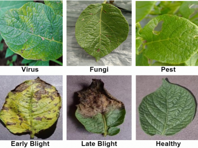
The potato plant disease detection dataset comprises 5,748 images of potato leaves categorized into six classes: Early Blight (1,000), Fungi (748), Healthy (1,000), Late Blight (1,000), Pest (1,000), and Virus (1,000). The dataset was collected from various open-access sources and integrated class-wise for comprehensive analysis. This dataset provides a robust foundation for training and evaluating convolutional neural networks in plant disease detection.
- Categories:
987 Views
This dataset contains simulated and real-world experimental data associated with the paper “Comprehensive Analysis of Optimization-Based Obstacle Avoidance for Agricultural Robotics in Greenhouse Environments.” The dataset from the simulated environment comprises multiple CSV files generated from the Gazebo simulation of a differential robot, the Stretch Robot. These files document the robot's movement, capturing data from the Gazebo model topic.
- Categories:
32 Views
This dataset contains simulated and real-world experimental data associated with the paper “Comprehensive Analysis of Optimization-Based Obstacle Avoidance for Agricultural Robotics in Greenhouse Environments.” The dataset from the simulated environment comprises multiple CSV files generated from the Gazebo simulation of a differential robot, the Stretch Robot. These files document the robot's movement, capturing data from the Gazebo model topic.
- Categories:
13 Views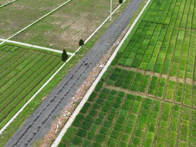
This is a wheat breeding phenotyping and yield dataset, including canopy height (CH, m), canopy volume (CV, m3), and leaf area index (LAI) collected in the field; vegetation index (VI) generated by multispectral data acquired by UAV remote sensing; trial site weather (Weather); and yield (Yield, kg). The data comes from field trials.
Data acquisition and processing are described in the relevant part of the manuscript.
- Categories:
294 Views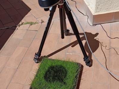
Hyperspectral imaging (HSI) has become a pivotal tool for environmental monitoring, particularly in identifying and analyzing hydrocarbon spills. This study presents an Internet of Things (IoT)-based framework for the collection, management, and analysis of hyperspectral data, employing a controlled experimental setup to simulate hydrocarbon contamination. Using a state-of-the-art hyperspectral camera, a dataset of 116 images was generated, encompassing temporal and spectral variations of gasoline, thinner, and motor oil spills.
- Categories:
289 Views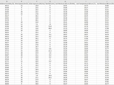
The data is collected from the deployed IoT sensor node at a pilot farm in Narrabri, Australia. The dataset includes information about soil characteristics such as soil moisture and soil temperature at 20-40-60 cm depth. The sensor node also provides information about environmental influencers, which are critical in constructing machine learning models to predict Evapotranspiration in diverse soil and environmental conditions.
- Categories:
777 Views