Image Processing
WITH the advancement in sensor technology, huge amounts of data are being collected from various satellites. Hence, the task of target-based data retrieval and acquisition has become exceedingly challenging. Existing satellites essentially scan a vast overlapping region of the Earth using various sensing techniques, like multi-spectral, hyperspectral, Synthetic Aperture Radar (SAR), video, and compressed sensing, to name a few.
- Categories:
 1681 Views
WITH the advancement in sensor technology, huge amounts of data are being collected from various satellites. Hence, the task of target-based data retrieval and acquisition has become exceedingly challenging. Existing satellites essentially scan a vast overlapping region of the Earth using various sensing techniques, like multi-spectral, hyperspectral, Synthetic Aperture Radar (SAR), video, and compressed sensing, to name a few.
- Categories:
 49 Views
WITH the advancement in sensor technology, huge amounts of data are being collected from various satellites. Hence, the task of target-based data retrieval and acquisition has become exceedingly challenging. Existing satellites essentially scan a vast overlapping region of the Earth using various sensing techniques, like multi-spectral, hyperspectral, Synthetic Aperture Radar (SAR), video, and compressed sensing, to name a few.
- Categories:
 463 Views
WITH the advancement in sensor technology, huge amounts of data are being collected from various satellites. Hence, the task of target-based data retrieval and acquisition has become exceedingly challenging. Existing satellites essentially scan a vast overlapping region of the Earth using various sensing techniques, like multi-spectral, hyperspectral, Synthetic Aperture Radar (SAR), video, and compressed sensing, to name a few.
- Categories:
 313 Views
With the advancement in sensor technology, huge amounts of data are being collected from various satellites. Hence, the task of target-based data retrieval and acquisition has become exceedingly challenging. Existing satellites essentially scan a vast overlapping region of the Earth using various sensing techniques, like multi-spectral, hyperspectral, Synthetic Aperture Radar (SAR), video, and compressed sensing, to name a few.
- Categories:
 339 Views
With the advancement in sensor technology, huge amounts of data are being collected from various satellites. Hence, the task of target-based data retrieval and acquisition has become exceedingly challenging. Existing satellites essentially scan a vast overlapping region of the Earth using various sensing techniques, like multi-spectral, hyperspectral, Synthetic Aperture Radar (SAR), video, and compressed sensing, to name a few.
- Categories:
 396 Views
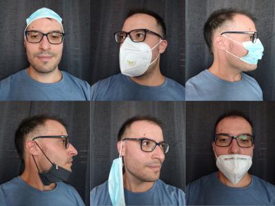
The Ways To Wear a Mask or a Respirator Database (WWMR-DB) is a test database that can be used to compare the behavior of current mask detection systems with images that most closely resemble the real case. It consists of 1222 images divided into 8 classes, depicting the most common ways in which masks or respirators are worn:
- Mask Or Respirator Not Worn
- Mask Or Respirator Correctly Worn
- Mask Or Respirator Under The Nose
- Mask Or Respirator Under The Chin
- Mask Or Respirator Hanging From An Ear
- Mask Or Respirator On The Tip Of The Nose
- Categories:
 3020 Views
Computer-assisted intraoperative intraocular lens (IOL) positioning and alignment is a valuable study. It is important to precisely position and align the axis of IOL during surgery to achieve optimal post-operative astigmatism correction. The cataract surgery dataset is proposed in the research paper “Computer-aided Intraoperative Toric Intraocular Lens Positioning and Alignment During Cataract Surgery”.
- Categories:
 1864 Views
TEST6
- Categories:
 126 Views
TEST
- Categories:
 134 Views


