Geomorphic Parameters
- Citation Author(s):
-
Khan Zada

- Submitted by:
- Khan Zada
- Last updated:
- DOI:
- 10.21227/912t-3107
- Data Format:
 6 views
- Categories:
- Keywords:
Abstract
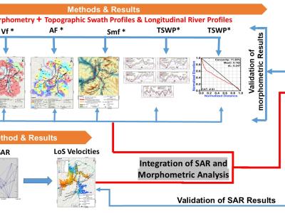
Abstract—This study evaluates the long-term tectonic influence on landform development as well as the present-day tectonic activity in the Nanga Parbat-Haramosh Syntaxis (NPHS), a geologically complex region in the northwestern Himalayas. Using geomorphic indices and remote sensing techniques, including Interferometric Synthetic Aperture Radar (InSAR) and existing Global Positioning System (GPS) data, this research identifies significant neotectonic deformation, with active faults contributing to slope hazards and seismic risks. Geomorphic analysis reveals a landscape dominated by active tectonics, indicating a predominantly mature and/or intransient stage of geomorphic development. InSAR-derived deformation velocities, ranging from -50 mm/year to +20 mm/year, corroborate geomorphic evidence and highlight unstable zones, particularly along major fault zones like the Liachar – Raikot section of the Raikot - Sassi Fault zone as well as the Stak Fault Zones. These findings emphasize the interplay between tectonic forces and surface processes in shaping the NPHS landscape. The study underscores implications for ongoing and future infrastructure projects in the area, particularly concerning the China-Pakistan Economic Corridor (CPEC), necessitating detailed hazard assessments. Additionally, this research contributes to broader geological models applicable to similar orogenic belts worldwide and highlight the need for continued research into neotectonic activity in seismically active regions like NPHS.
Instructions:
This is research base data, here it is uploaded as one of the paper requirements to the IEEE-TGRS, so it can only be used with the approval of the authors after publication of the paper.