Climate Change/Environmental


We used Sentinel-2 images to create the dataset In order to estimate sequestered carbon in the above-ground forest Biomass. Moreover, fieldwork was completed to gather related forest biomass volume. The clipped image has a size of 1115 × 955 pixels and consists of bands 3, 4, and 8, which correspond to green, red, and near-infrared.
- Categories:
 1064 Views
- Categories:
474 Views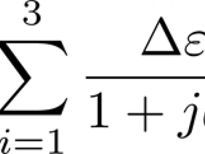
The dataset contains fitted three-pole Debye dielectric model parameters of 567 soil spectra. Three soils of loamy sand, sandy loam, and silt loam textures were tested. Of each soil, 20 samples of various water contents were prepared with the use of distilled water and potassium chloride solutions, 5 samples for each liquid. Air-dry samples were also prepared. Dielectric spectra were obtained with the use of a six-channel coaxial-transmission-line cell system at 9 controlled temperature steps from 0.5 to 40°C in the 0.02 – 3 GHz frequency range.
- Categories:
217 Views
LSD4WSD: Learning SAR Dataset for Wet Snow Detection.
The dataset can be found at : https://zenodo.org/record/8111485
- Categories:
198 Views
Photo identification (photoID) is a non-invasive technique devoted to the identification of individual animals using photos, and it is based on the hypothesis that each specimen has unique features useful for its recognition. This technique is particularly suitable to study highly mobile and hard to detect marine species, such as cetaceans. These animals play a key role in marine biodiversity conservation because they maintain the stability and health of marine ecosystems due to their apical role as top predators in food webs.
- Categories:
979 Views
This dataset contains supporting information regarding the LCA modeling carried out in the scientific paper "Technical and Ecological Limits of 2.45-GHz Wireless Power Transfer for Battery-Less Sensors".
- Categories:
295 Views
CAMP version used for the measurements of the GPU Linear solver Biconjugate Gradient, and the Block-cells strategy. Latest developments at https://github.com/open-atmos/camp
- Categories:
92 Views
The Paddy Doctor dataset contains 16,225 labeled paddy leaf images across 13 classes (12 different paddy diseases and healthy leaves). It is the largest expert-annotated visual image dataset to experiment with and benchmark computer vision algorithms. The paddy leaf images were collected from real paddy fields using a high-resolution (1,080 x 1,440 pixels) smartphone camera. The collected images were carefully cleaned and annotated with the help of an agronomist.
- Categories:
11938 Views
The problem of effective disposal of the trash generated by people has rightfully attracted major interest from various sections of society in recent times. Recently, deep learning solutions have been proposed to design automated mechanisms to segregate waste. However, most datasets used for this purpose are not adequate. In this paper, we introduce a new dataset, TrashBox, containing 17,785 images across seven different classes, including medical and e-waste classes which are not included in any other existing dataset.
- Categories:
1060 Views