Image Processing

Sign languages are the most common mode of communication with and between hearing-impaired individuals. In the Arab world, Arabic sign language is used with different dialects supporting a distinct set of rules for the gestures used. With research on natural language processing advancing, models have been developed to translate sign language to spoken language and vice versa. However, Arabic sign language has rarely been studied due to the lack of availability of datasets dealing with Arabic sign language.
- Categories:
 1973 Views
<p>Images from Sentinel 2 for dehazing. Contains 3 folders, one with original images, one with dehazed images at default exponent of 0.8 and the last with failed images with fine tuned exponent (thus becoming successful).</p>
- Categories:
27 Views
We uploaded the raw collected fish image data used for model training. These data were divided into those in simple and complex background. In total, there are more than 800 images.
- Categories:
171 Views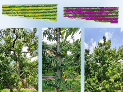
This cherry tree disease detection dataset is a multimodal, multi-angle dataset which was constructed for monitoring the growth of cherry trees, including stress analysis and prediction. An orchard of cherry trees is considered in the area of Western Macedonia, where 577 cherry trees were recorded in a full crop season starting from Jul. 2021 to Jul. 2022. The dataset includes a) aerial / Unmanned Aerial Vehicle (UAV) images, b) ground RGB images/photos, and c) ground multispectral images/photos.
- Categories:
2798 Views
This dataset contains bone scan image and its segmentation mask. The segmentation mask is made for the purpose of detecting metastases on bone scan images
- Categories:
728 Views
We create a thermal infrared face dataset (TIF) for fever screening. TIF is collected at the entrance of our university’s engineering building. The infrared face images are captured by an infrared camera under different environmental conditions.
- Categories:
962 Views
Due to the smaller size, low cost, and easy operational features, small unmanned aerial vehicles (SUAVs) have become more popular for various defense as well as civil applications. They can also give threat to national security if intentionally operated by any hostile actor(s). Since all the SUAV targets have a high degree of resemblances in their micro-Doppler (m-D) space, their accurate detection/classification can be highly guaranteed by the appropriate deep convolutional neural network (DCNN) architecture.
- Categories:
6224 Views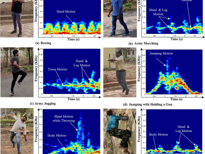
In the view of national security, radar micro-Doppler (m-D) signatures-based recognition of suspicious human activities becomes significant. In connection to this, early detection and warning of terrorist activities at the country borders, protected/secured/guarded places and civilian violent protests is mandatory.
- Categories:
6301 Views
The dataset of satellite images we use comes from Satellite Tool Kit (STK), which is the world's top satellite simulation software produced by AGI Company of the United States. We mainly use STK to provide a high-precision visual simulation module, which can provide users with high-fidelity visual support in space. We collected 18 video sequences as our training set and 6 video sequences as our verification set. A video sequence contains a satellite, and each video sequence contains 40 to 60 satellite images.
- Categories:
156 Views
This is a regional time-series image datasets, which contains four regions in WRS-2 (36/129 region, 36/130 region, 37/129 region, and 37/130 region).
- Categories:
355 Views