Weather

SETCD (Satellite and ERA5-based Tropical Cyclone Dataset), a comprehensive dataset encompassing satellite imagery data and ERA5 data for all TCs recorded between 1980 and 2022. Our dataset is derived from two publicly available data sources: GridSat-B1 and ERA5. To capture relevant information associated with TC, SETCD adopts the latitude and longitude positions provided by IBTrACS as the center points. The satellite data within the SETCD dataset consists of three channels from GridSat-B1: infrared, water vapor, and visible.
- Categories:
 303 Views
This data is the reanalysis of sea surface temperature provided by Extended Reconstruction Sea Surface Temperature version 5 (ERSST v.5) from January 1854 to December 2022, Hadley Centre Global Sea Ice and Sea Surface Temperature (HadISST) from January 1870 to December 2022, and COBE-SST2 Sea Surface Temperature and Ice (COBE-SST2) from January 1854 to December 2022. All data is re-gridded to have the same spatial resolution of 2.0° × 2.0°, and the grid spans from 88°N to 88°S and 0°E to 358°E via bilinear interpolation from the initial grid. This dataset is in NetCDF4 format.
- Categories:
120 Views
To improve the comprehensive monitoring and early warning capabilities for typhoons, heavy rain, sea fog, and other severe weather in the SCS region, the China Meteorological Administration has established a variety of observation stations, including automatic weather stations (AWS), buoy stations (BS), radiosondes, and weather radars in the SCS region. The surface bulk measurements from April 2019 to November 2021 used in Hainan were collected by 5 Buoys.
- Categories:
84 Views
Yongxing Island is located south of the Tropic of Cancer and has a tropical monsoon climate. Due to being surrounded by the sea and having a small land area, it has the characteristics of a maritime climate. Located around 100m off the northeastern coast of Yongxing Island, the Yongxing air–sea flux tower (YXASFT) stands at the height of 20m and was specifically designed for observing air-sea boundary layer fluxes. A CR3000 data logger manufactured by Campbell Scientific Company, USA, is used for data sampling, preprocessing, storage, and transmission.
- Categories:
67 Views
This data repository comprises three distinct datasets tailored for different predictive modeling tasks. The first dataset is a synthetic dataset designed to simulate multivariate time series patterns, incorporating both linear and non-linear dependencies among input and target features. The second dataset, the Beijing Air Quality PM2.5 dataset, consists of PM2.5 measurements alongside meteorological data like temperature, humidity, and wind speed, with the objective of predicting PM2.5 concentrations.
- Categories:
411 Views
As the harmful effects of climate change on human society increase, the analysis of abnormal weather is becoming an important issue. Therefore, this work provides the Korean weather dataset, including the anomaly score measurements by using seven different methods. In this dataset, seven types of weather data for each day in 64 Korean cities from 2010 to 2020 are provided by Weather Radar Center in Korea Meteorological Administration.
- Categories:
250 Views
The first Algerian forest fires dataset consist of data on forest fires occurrence in Algeria related to meteorological observations and the fire weather indices. Our dataset includes mainly the daily meteorological observations and the Fire Weather Index (FWI) system components. Given the lack of publically available datasets on data on forest fires occurrence in Algeria we have created this one to study the feasibility of the appliance of machine learning algorithms as models for forest fires prediction in the context of Algeria.
- Categories:
1140 Views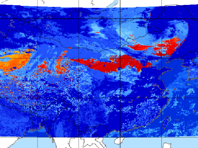
Since meteorological satellites can observe the Earth’s atmosphere from a spatial perspective at a large scale, in this paper, a dust storm database is constructed using multi-channel and dust label data from the Fengyun-4A (FY-4A) geosynchronous orbiting satellite, namely, the Large-Scale Dust Storm database based on Satellite Images and Meteorological Reanalysis data (LSDSSIMR), with a temporal resolution of 15 minutes and a spatial resolution of 4 km from March to May of each year during 2020–2022.
- Categories:
872 Views

Seven years of water consumption data, along with population data, were manually collected in collaboration with the local municipality office. This data was then combined with climatic data to model the proposed machine learning algorithm. The weather data was recorded for a period of 7 years using precise meteorological instruments installed in Islamabad at coordinates 33.64° N and 72.98° E, with an elevation of 500 meters above sea level.
- Categories:
779 Views