Transportation

Unmanned aerial vehicles (UAVs) are being used for various applications, but the associated cyber risks are also increasing. Machine learning techniques have been successfully adopted to develop intrusion detection systems (IDSs). However, none of the existing works published the cyber or physical datasets that have been used to develop the IDS, which hinders further research in this field.

Categories:

The dataset contains a collection of V2X (Vehicle-to-Everything) messages for classification, prioritization, and spam message detection. It comprises 1,000 messages with varying message types, content, priorities, and spam labels. The messages are sourced from different vehicles with specific destination vehicles or broadcast to all vehicles. They cover various message types, including traffic updates, emergency alerts, weather notifications, hazard warnings, roadwork information, and spam messages. The priority of the messages is categorized as either high, medium, or low.

Categories:

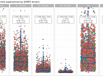
The Surface Accelerations Reference is a catalog of all longitudinal and lateral accelerations experienced by SHRP2-NDS participants. The Strategic Highway Research Program Naturalistic Driving Study (SHRP2-NDS) is the largest naturalistic driving study in the world constituting of 34.5 million miles of recorded driving data. To create the surface accelerations reference, each and every acceleration event in SHRP2-NDS was detected, summarized, and recorded creating a database of more than 1.7 billion data points.

Categories:

SWAN is a large-scale outdoor point cloud semantic segmentation, instance segmentation and object detection dataset.  The dataset is targeted explicitly at the challenging urban environment, which aligns well with the needs of the intelligent transportation systems. The data is collected in the Central Business District (CBD) of Perth city in Australia, covering nearly 150km. It additionally used specialized equipment (portable trolley) to capture scenes of no-through roads and narrow streets.

Categories:
SWAN is a Large-Scale Outdoor Point Cloud semantic segmentation dataset .  The dataset is targeted explicitly at the challenging urban environment, which aligns well with the needs of the intelligent transportation systems. The data is collected in the Central Business District (CBD) of Perth city in Australia, covering nearly 150km. It additionally used specialized equipment (portable trolley) to capture scenes of no-through roads and narrow streets.
Categories:

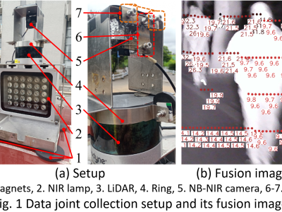
In nighttime driving scenes, due to insufficient and uneven lighting, and the scarcity of high-quality datasets, the miss rate of nighttime pedestrian detection (PD) is much higher than that of daytime. Vision-based distance detection (DD) has the advantages of low cost and good interpretability, but the existing methods have low precision, poor robustness, and the DD is mostly performed independently of PD.

Categories: