Machine Learning

In the captured image, a drone is seen in flight, displaying its advanced technological features and capabilities. The image highlights the drone's robust design and aerodynamic structure, which are essential for its diverse applications in research and development. Drones, also known as Unmanned Aerial Vehicles (UAVs), are increasingly being utilized in various fields due to their ability to collect data from hard-to-reach or hazardous areas.
- Categories:
 7 Views
This datasets include six kinds of data, they are sea surface temperature, sea surface height, sea surface salinity, sea surface density, and current velocity in two directions. These physical variables are obtained from high-resolution observations, which can offer important understanding of the physical processes that affect SST variations. The study area spans from 5N to 5S in latitude and from 160W to 170W in longitude. The data used have a spatial resolution of 0.05 degree.
- Categories:
 13 Views
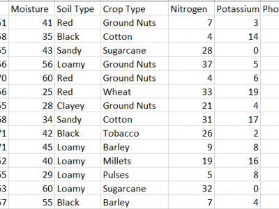
This dataset provides comprehensive data for predicting the most suitable fertilizer for various crops based on environmental and soil conditions. It includes environmental factors like temperature, humidity, and moisture, along with soil and crop types, and nutrient composition (Nitrogen, Potassium, and Phosphorous). The target variable is the recommended fertilizer name.
The data is already pre-processed without anu Null values.
- Categories:
 114 Views
In this paper we use Natural Language Processing techniques to improve different machine learning approaches (Support Vector Machines (SVM), Local SVM, Random Forests) to the problem of automatic keyphrases extraction from scientific papers. For the evaluation we propose a large and high-quality dataset: 2000 ACM papers from the Computer Science domain. We evaluate by comparison with expert-assigned keyphrases.
- Categories:
 9 Views
Hyperspectral images are represented by numerous
narrow wavelength bands in the visible and near-infrared parts
of the electromagnetic spectrum. As hyperspectral imagery gains
traction for general computer vision tasks, there is an increased
need for large and comprehensive datasets for use as training
data.
Recent advancements in sensor technology allow us to capture
hyperspectral data cubes at higher spatial and temporal reso-
lution. However, there are few publicly available multi-purpose
- Categories:
 47 Views
The necessity for strong security measures to fend off cyberattacks has increased due to the growing use of Industrial Internet of Things (IIoT) technologies. This research introduces IoTForge Pro, a comprehensive security testbed designed to generate a diverse and extensive intrusion dataset for IIoT environments. The testbed simulates various IIoT scenarios, incorporating network topologies and communication protocols to create realistic attack vectors and normal traffic patterns.
- Categories:
 84 Views
We present a publicly available dataset of keypoints for multimodal retinal image registration using Color Fundus (CF) and Fractional Anisotropy (FA) images. This dataset is derived from the diabetic retinal image dataset [1], consisting of 59 subjects (29 healthy controls and 30 diabetic patients). The CF images are captured in RGB, while FA images, highlighting microvascular structures, are provided in grayscale, both at a resolution of 720 × 576 pixels.
- Categories:
 24 Views
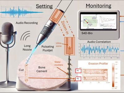
This dataset comprises extensive multi-modal data related to the experimental study of ultrasonically excited pulsating fluid jets used for bone cement removal. Conducted at the Institute of Geonics, Ostrava, Czech Republic, the study explores the effect of varying standoff distances on erosion profiles, under controlled parameters including a fixed nozzle diameter, sonotrode frequency, supply pressure, and robot arm velocity. The dataset includes numerical data representing ablation profiles, captured as a large CSV file, and audio recordings captured using a high-resolution microphone.
- Categories:
 111 Views
The IARPA WRIVA program aims to develop software systems that can create photorealistic, navigable 3D site models using a highly limited corpus of imagery, to include ground level imagery, surveillance height imagery, airborne altitude imagery, and satellite imagery. Additionally, where imagery lacks metadata indicating geolocation, information about camera parameters, or is corrupted by artifacts, WRIVA seeks to detect and correct these factors to incorporate the imagery in site-modelling and other downstream image processing and analysis algorithms.
- Categories:
 71 Views
M. Kacmajor and J.D. Kelleher, "ExTra: Evaluation of Automatically Generated Source Code Using Execution Traces" (submitted to IEEE TSE)
- Categories:
 16 Views

