Image Processing
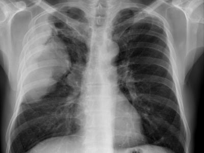
The dataset is genrated by the fusion of three publicly available datasets: COVID-19 cxr image (https://github.com/ieee8023/covid-chestxray-dataset), Radiological Society of North America (RSNA) (https://www.kaggle.com/c/rsna-pneumonia-detection-challenge), and U.S. national library of medicine (USNLM) collected Montgomery country - NLM(MC) (http
- Categories:
 1977 Views
The current maturity of autonomous underwater vehicles (AUVs) has made their deployment practical and cost-effective, such that many scientific, industrial and military applications now include AUV operations. However, the logistical difficulties and high costs of operating at-sea are still critical limiting factors in further technology development, the benchmarking of new techniques and the reproducibility of research results. To overcome this problem, we present a freely available dataset suitable to test control, navigation, sensor processing algorithms and others tasks.
- Categories:
 4297 Views
Results(including reported and extra results) for LSstab. Please refer to our paper "Efficient real-time video stabilization with a novel least squares formulation and parallel AC-RANSAC".
- Categories:
 166 Views
This dataset is flotation froth sequence images, a total of 2386 folders, that is, 2386 groups of froth sequence images. The data comes from a mine in southern China, and the digital camera collected the froth videos every 5 minutes during the period from 2019.08.01 to 2019.12.01. Each group of froth sequence images contains 12 consecutive frames and the sampling time is 0.4s. This dataset is suitable for image processing, pattern recognition, and artificial intelligence.
- Categories:
 1289 Views
Deep learning undoubtedly has had a huge impact on the computer vision community in recent years. In light field imaging, machine learning-based applications have significantly outperformed their conventional counterparts. Furthermore, multi- and hyperspectral light fields have shown promising results in light field-related applications such as disparity or shape estimation. Yet, a multispectral light field data\-set, enabling data-driven approaches, is missing. Therefore, we propose a new synthetic multispectral light field dataset with depth and disparity ground truth.
- Categories:
 1947 Views
ALL-IDB (Acute Lymphoblastic Leukemia) Image Database for Image Processing
ALL-IDB dataset comprises of two subsets among them one subset has 260 segmented lymphocytes of them 130 belongs to the leukaemia and the remaining 130 belongs to the non leukaemuia class it requires only classification. second subset has around 108 non segmented blood images that belongs to the leukaemia and non leukaemia groups thus requires segmentation and classification.
- Categories:
 3009 Views


