Datasets
Open Access
SEN12-FLOOD : a SAR and Multispectral Dataset for Flood Detection
- Citation Author(s):
- Submitted by:
- Clement Rambour
- Last updated:
- Thu, 12/10/2020 - 06:19
- DOI:
- 10.21227/w6xz-s898
- Data Format:
- Links:
- License:
 13884 Views
- Categories:
- Keywords:
Abstract
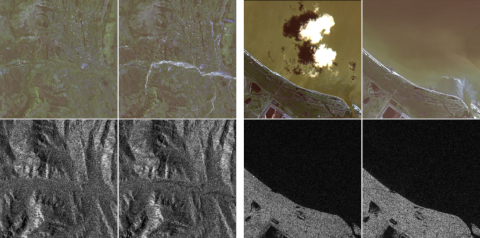
These last decades, Earth Observation brought quantities of new perspectives from geosciences to human activity monitoring. As more data became available, artificial intelligence techniques led to very successful results for understanding remote sensing data. Moreover, various acquisition techniques such as Synthetic Aperture Radar (SAR) can also be used for problems that could not be tackled only through optical images. This is the case for weather-related disasters such as floods or hurricanes, which are generally associated with large clouds cover. Yet, machine learning on SAR data is still considered challenging due to the lack of available labeled data. This dataset is composed of co-registered optical and SAR images time series for the detection of flood events.
The dataset is composed of 336 sequences corresponding to areas in West and South-East Africa, Middle-East, and Australia. Each time series is located in a given folder named with the sequence ID (0001... 0336).
Two json files, S1list.json and S2list.json are provided to describe respectively the Sentinel-1 and Sentinel-2 images.
The keys are the total number of images in the sequence, the folder name, the geography of the observed area, and the description of each image in the series. The SAR images description contains also the URLs to download the images.
Each image is described by its acquisition date, its label (FLOODING: boolean), a boolean (FULL-DATA-COVERAGE: boolean) indicating if the area is fully or partially imaged, and the file prefix. For SAR images the orbit (ASCENDING or DESCENDING) is also indicated.
The Sentinel-2 images were obtained from the Mediaeval 2019 Multimedia Satellite Task [1] and are provided with Level 2A atmospheric correction. For one acquisition, there are 12 single-channel raster images provided corresponding to the different spectral bands.
The Sentinel-1 images were added to the dataset. The images are provided with radiometric calibration and range doppler terrain correction based on the SRTM digital elevation model. For one acquisition, two raster images are available corresponding to the polarimetry channels VV and VH.
The original dataset was split into 269 sequences for the train and 68 sequences for the test. Here all sequences are in the same folder.
To use this dataset please cite the following papers:
Flood Detection in Time Series of Optical and SAR Images, C. Rambour,N. Audebert,E. Koeniguer,B. Le Saux, and M. Datcu, ISPRS - International Archives of the Photogrammetry, Remote Sensing and Spatial Information Sciences, 2020, 1343--1346
The Multimedia Satellite Task at MediaEval2019, Bischke, B., Helber, P., Schulze, C., Srinivasan, V., Dengel, A.,Borth, D., 2019, In Proc. of the MediaEval 2019 Workshop
This dataset contains modified Copernicus Sentinel data [2018-2019], processed by ESA.
[1] The Multimedia Satellite Task at MediaEval2019, Bischke, B., Helber, P., Schulze, C., Srinivasan, V., Dengel, A.,Borth, D., 2019, In Proc. of the MediaEval 2019 Workshop
Dataset Files
SEN12FLOOD.zip (12.20 GB)
Open Access dataset files are accessible to all logged in users. Don't have a login? Create a free IEEE account. IEEE Membership is not required.


Comments
ok