Sentinel-1
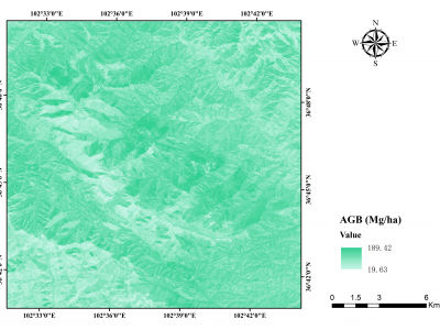
Aboveground biomass (AGB) is a vital indicator for studying the carbon sink in forest ecosystems. Semi-arid forests harbor substantial carbon storage but received little attention as high spatial-temporal heterogeneity. This study assessed the performance of different data sources (annual monthly time-series radar: Sentinel-1 (S1), annual monthly time-series optical: Sentinel-2 (S2), and single-temporal airborne LiDAR) and seven prediction approaches to map AGB in the semi-arid forests at the border between Gansu and Qinghai provinces in China.
- Categories:
 139 Views
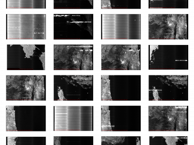
Synthetic Aperture Radar (SAR) satellite images are used increasingly more for Earth observation. While SAR images are useable in most conditions, they occasionally experience image degradation due to interfering signals from external radars, called Radio Frequency Interference (RFI). RFI affected images are often discarded in further analysis or pre-processed to remove the RFI.
- Categories:
348 Views
The files here support the analysis presented in the Comment on “Study of Systematic Bias in Measuring Surface Deformation With SAR Interferometry” by Ansari et al. (2021), published in IEEE Transactions on Geoscience and Remote Sensing [1]. In particular, we provide in the following the instructions to access the multilook interferogram sequences exploited in our Comment and their ancillary information.
This dataset contains modified Copernicus Sentinel data [2021].
- Categories:
552 Views
These last decades, Earth Observation brought quantities of new perspectives from geosciences to human activity monitoring. As more data became available, artificial intelligence techniques led to very successful results for understanding remote sensing data. Moreover, various acquisition techniques such as Synthetic Aperture Radar (SAR) can also be used for problems that could not be tackled only through optical images. This is the case for weather-related disasters such as floods or hurricanes, which are generally associated with large clouds cover.
- Categories:
13905 Views