Remote Sensing
Extracting ships from complex backgrounds is the bottleneck of ship detection in high-resolution optical satellite images. In this letter, we propose a nearly closed-form ship rotated bounding box space used for ship detection and design a method to generate a small number of highly potential candidates based on this space. We first analyze the possibility of accurately covering all ships by labeling rotated bounding boxes. Moreover, to reduce search space, we construct a nearly closed-form ship rotated bounding box space.
- Categories:
 76 Views
Substantial efforts have been devoted more recently to presenting various methods for object detection in optical remote sensing images. However, the current survey of datasets and deep learning based methods for object detection in optical remote sensing images is not adequate. Moreover, most of the existing datasets have some shortcomings, for example, the numbers of images and object categories are small scale, and the image diversity and variations are insufficient. These limitations greatly affect the development of deep learning based object detection methods.
- Categories:
85 Views
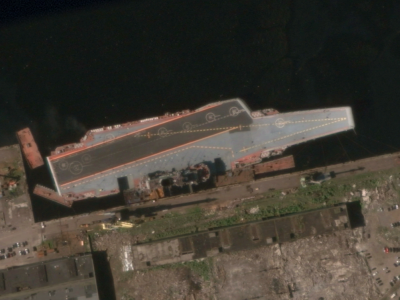
This study utilizes the open-source datasets FAIR1M and HRSC2016 as foundational resources to construct an optical remote sensing image dataset for rotated ship target detection. The dataset encompasses nine ship categories: Dry-Cargo-Ship, Engineering-Ship, Fishing-Boat, Motorboat, Tugboat, Passenger-Ship, Warship, Liquid-Cargo-Ship, and Other-Ship.
- Categories:
30 Views
Geohazards resulting from mining activities must be effectively monitored to mitigate their impact on the environment and human activities. Geohazards such as landslides and collapses caused by open-pit mining are relatively easier to monitor because they are primarily surface-based. In contrast, underground mining disrupts the stress balance in the overlying rock layers, leading to complex settlement patterns, including subsidence basins, cracks, and groundwater depletion.
- Categories:
14 Views
Data associated with the article: "PM2.5 Retrieval with Sentinel-5P Data over Europe Exploiting Deep Learning"
- Categories:
23 Views
The HROS dataset consists of OPT and SAR images collected from multiple sources. The OPT images are collected from the large-scale public remote sensing datasets. Image sources include different platforms, including Google Maps, JL-1 satellite, Gaofen-2 satellite, aerial imagery, etc. The SAR images are captured by the AS-01 satellite, developed by Skysight Technology Co., LTD. The AS-01 satellite is equipped with a two-dimensional scanning plane solid-state active phased array synthetic aperture radar (SAR) payload, which enables high-resolution imaging capabilities.
- Categories:
47 Views
Greenland Ice Sheet is one of the key factors influencing global climate change. Its slight variations can lead to significant changes in sea level, making quantitative research on its mass balance of great scientific importance.
- Categories:
12 Views
Greenland Ice Sheet is one of the key factors influencing global climate change. Its slight variations can lead to significant changes in sea level, making quantitative research on its mass balance of great scientific importance.
- Categories:
Views
Greenland Ice Sheet is one of the key factors influencing global climate change. Its slight variations can lead to significant changes in sea level, making quantitative research on its mass balance of great scientific importance.
- Categories:
4 Views
These are 3D contours from LiDAR point cloud of Las Vegas. The QL-1 datasets (≤10cm vertical/≤35cm horizontal accuracy, ≥8 points/m²) required preprocessing due to excessive data volume (142GB for Santa Clara alone). Our method reduces data while preserving structurally critical line features for satellite image-LiDAR point cloud registration, focusing on building contours rather than less prominent road edges. First, building footprints were extracted using Google's 2D shape vectors instead of raw segmentation or classification.
- Categories:
9 Views