Datasets
Open Access
FLAME 3 - Radiometric Thermal UAV Imagery for Wildfire Management
- Citation Author(s):
- Submitted by:
- IS-WiN Lab
- Last updated:
- Sun, 12/22/2024 - 15:33
- DOI:
- 10.21227/w0mz-aq48
- Data Format:
- Link to Paper:
- Links:
- License:
 2235 Views
- Categories:
- Keywords:
Abstract
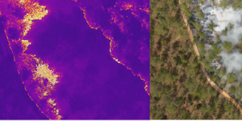
FLAME 3 is the third dataset in the FLAME series of aerial UAV-collected side-by-side multi-spectral wildlands fire imagery (see FLAME 1 and FLAME 2). This set contains a single-burn subset of the larger FLAME 3 dataset focusing specifically on Computer Vision tasks such as fire detection and segmentation. Included are 622 image quartets labeled Fire and 116 image quartets labeled No Fire. The No Fire images are of the surrounding forestry of the prescribed burn plot. Each image quartet is composed of four images - a raw RGB image, a raw thermal image, a corrected FOV RGB image, and a thermal TIFF. Each of the four data types are detailed in the below Table 1. More information on data collection methods, data processing procedures, and data labeling can be found in https://arxiv.org/abs/2412.02831.
This dataset also contains a NADIR Thermal Fire set, providing georeferenced overhead thermal imagery, captured by UAV every 3-5 seconds, focusing on monitoring fire progression and burn behaviors over time. This data, when processed, enables centimeter-grade measurements of fire spread and energy release over time. Pre, post, and during burn imagery are included, along with ground control point (GCP) data.
This dataset is based on the research conducted in the paper: FLAME 3 Dataset: Unleashing the Power of Radiometric Thermal UAV Imagery for Wildfire Management. It provides detailed insights and analysis related to forest fire monitoring and modeling.
If you use this dataset in your research or projects, please cite the original paper as follows: APA: Hopkins, B., ONeill, L., Marinaccio, M., Rowell, E., Parsons, R., Flanary, S., Nazim I, Seielstad C, Afghah, F. (2024). FLAME 3 Dataset: Unleashing the Power of Radiometric Thermal UAV Imagery for Wildfire Management. arXiv preprint arXiv:2412.02831.
BibTeX: @misc{hopkins2024flame3datasetunleashing, title={FLAME 3 Dataset: Unleashing the Power of Radiometric Thermal UAV Imagery for Wildfire Management}, author={Bryce Hopkins and Leo ONeill and Michael Marinaccio and Eric Rowell and Russell Parsons and Sarah Flanary and Irtija Nazim and Carl Seielstad and Fatemeh Afghah}, year={2024}, eprint={2412.02831}, archivePrefix={arXiv}, primaryClass={cs.CV}, url={https://arxiv.org/abs/2412.02831}, }
FLAME 3 Computer Vision (CV) Subset
The CV subset contains imagery from the Sycan March prescribed burn. Each image from the burn is separated into a Fire or No Fire folder and then numbered and paired, with a raw RGB image, raw Thermal image, corrected FOV aligned RGB image, and a Thermal TIFF file. These image pairs can be utilized in a CNN-based or other vision-based model for Fire vs. No Fire classification, or further processed / labeled for a task such as fire segmentation. The organization of imagery, resolution, and description of each data type is described below.
FLAME 3 CV Subset Datatypes
-
Raw RGB Image
- Resolution: 4000 x 3000
- File Extension: .JPG
- Description: Unprocessed visual spectrum image collected simultaneously with the Raw Thermal Image.
-
Raw Thermal Image
- Resolution: 640 x 512
- File Extension: .JPG
- Description: Thermal image collected simultaneously with the Raw RGB Image. Regenerated from the Thermal TIFF to ensure thermal color palette consistency across dataset (preserving JPG meta-data).
-
Corrected FOV RGB Image
- Resolution: 640 x 512
- File Extension: .JPG
- Description: Copy of Raw RGB Image that has been translated, scaled, and cropped such that the image's pixels align with the Raw Thermal Image.
-
Thermal TIFF
- Resolution: 640 x 512
- File Extension: .TIFF
- Description: Raster of per-pixel Celsius temperature values. Maximum temperature saturates at approximately 500 degrees Celsius.
All of the images contained in this FLAME 3 subset were collected from a single prescribed fire at Sycan Marsh, Oregon between 10/25/23 and 10/27/23. All images were collected with a DJI M30T UAV.
Additional tools for processing the CV subset imagery can be found at the Github link here: https://github.com/BryceHopkins14/Flame-Data-Pipeline.
FLAME 3 NADIR Thermal Plot Set
The NADIR Thermal plot images are image pairs collected from the Hanna Hammock prescribed burn. The imagery is separated into three plots labeled 'plot1', 'plot2', and 'plot3'. Inside of each of these plot folders, the imagery is separated into 'preburn', 'duringburn', and 'postburn' folders. Each burn folder contains the following paired imagery seen below.
FLAME 3 NADIR Plot Imagery Datatypes
-
Raw RGB Image
- Resolution: 8000 x 6000
- File Extension: .JPG
- Description: Unprocessed visual spectrum image collected simultaneously with the Raw Thermal Image.
-
Raw Thermal Image
- Resolution: 640 x 512
- File Extension: .JPG
- Description: Thermal image collected simultaneously with the Raw RGB Image. Regenerated from the Thermal TIFF to ensure thermal color palette consistency across dataset (preserving JPG meta-data).
-
Raw Thermal IRG
- Resolution: 640 x 512
- File Extension: .IRG
- Description: File containing raw IR image data.
-
Raw Thermal TIFF
- Resolution: 640 x 512
- File Extension: .TIFF
- Description: Raster of per-pixel Celsius temperature values. Maximum temperature saturates at approximately 500 degrees Celsius.
All of the images contained in this FLAME 3 subset were collected from a single prescribed fire at Hanna Hammock, Florida. All images were collected with an Autel Robotics XT709. In the burn folders, a .txt file containing ground control point (GCP) information is included.
Additionally, in the 'metadata' folder, a prescribed burn map for Hanna Hammock and information related to the burn procedures are included.
Lastly, the 'GCP' folder contains .csv, .kml, and shapefiles related to the GCP's used for this burn.
More from this Author
Dataset Files
CVSubset.zip (6.23 GB)
NADIRPlots.zip (32.59 GB)
Open Access dataset files are accessible to all logged in users. Don't have a login? Create a free IEEE account. IEEE Membership is not required.


