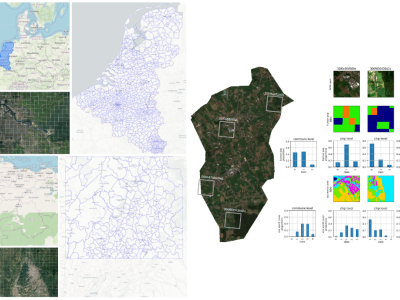
Deep Learning

We propose a coupled physics-driven and data-driven algorithm to improve standard deep learning workflow. In order to evaluate the proposed method, a 2.5D geological model including dip, fault and anisotropic formation is considered.  Comparing the inversion imaging performance of the proposed physics-driven method with the traditional classical residual network (Resnet), it shows a significant improvement in resistivity accuracy.

Categories:
  

This project builds a length-versatile and noise-robust LoRa radio frequency fingerprint identification (RFFI) system. The LoRa signals are collected from 10 commercial-off-the-shelf LoRa devices, with the spreading factor (SF) set to 7, 8, 9, respectively. The packet preamble part and device labels are provided.

Categories:

Detection of impact craters on the surface of Mars is a critical component in the study of Martian geomorphology and the evolution of the planet. As one of the most distinguishable geomorphic units on the Martian surface, accurate determination of the boundaries of impact craters provides valuable information in mapping and research efforts. The topography on Mars is more complex than that of the moon, making detection of real impact crater boundaries a challenging task.

Categories:

  We use industrial cameras to take images of steel wire ropes under different conditions, and use these wire rope images to train the U_Net network, and realize the semantic segmentation of the wire rope images by the U_Net network.

 
Categories:

The human gait is unique and so is the impact of a walking human on the propagation of wireless signals within a wireless network. Using appropriate pattern recognition techniques, a person can thus be identified just from a time series of Received Signal Strength (RSS) measurements. This dataset holds bidirectional RSS measurements recorded within a mesh network of four Bluetooth sensor devices. During the measurements, a total of 14 subjects walked individually through the setup. A total of more than 10,000 recordings are provided.

Categories:

Synthetic Aperture Radar (SAR) satellite images are used increasingly more for Earth observation. While SAR images are useable in most conditions, they occasionally experience image degradation due to interfering signals from external radars, called Radio Frequency Interference (RFI). RFI affected images are often discarded in further analysis or pre-processed to remove the RFI.

Categories:

Recently, a limited number of datasets that exist are used to detect errors in the printing process of the 3D printer. Limited datasets lead most researchers to dive into sensor data fault classification.

The dataset is captured and labelled before being fed to the DL model. The image dataset is captured in a time-lapse video mode with a 15-second duration for each printing process. Next, the time-lapse is used to extract around 50 images per video. In total, 2297 images containing four classes are collected.

Categories: