Computer Vision

We build an original dataset of thermal videos and images that simulate illegal movements around the border and in protected areas and are designed for training machines and deep learning models. The videos are recorded in areas around the forest, at night, in different weather conditions – in the clear weather, in the rain, and in the fog, and with people in different body positions (upright, hunched) and movement speeds (regu- lar walking, running) at different ranges from the camera.
- Categories:
 11076 Views
Mosquito bites result in the deaths of more than 1 million people every year. Certain species of mosquitos like Aedes are the main vector of arboviruses that cause Dengue, Malaria and Yellow fever. Image based mosquito species classification can be helpful to implement strategies to prevent the spread of mosquito borne disease. Automated mosquito species classification can aid in laborious and time consuming task of entomologists besides enhancing accuracy.
- Categories:
2795 Views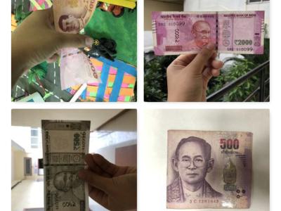
Recognition and classification of currency is one of the important task. It is a very crucial task for visually impaired people. It helps them while doing day to day financial transactions with shopkeepers while traveling, exchanging money at banks, hospitals, etc. The main objectives to create this dataset were:
1) Create a dataset of old and new Indian currency.
2) Create a dataset of Thai Currency.
3) Dataset consists of high-quality images.
- Categories:
3916 Views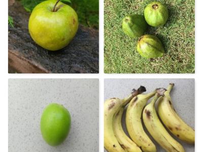
INDIA is the second-largest fruit and vegetable exporter in the world after China. It ranked first in the production of Bananas, Papayas, and Mangoes. Public datasets of fruits are available but they are limited to general fruit classes and failed to classify the fruits according to the fruit quality. To overcome this problem, we have created a dataset named FruitsGB (Fruits Good/Bad) dataset.
- Categories:
6625 Views
Recently, self-driving vehicles have been introduced with several automated features including lane-keep assistance, queuing assistance in traffic-jam, parking assistance and crash avoidance. These self-driving vehicles and intelligent visual traffic surveillance systems mainly depend on cameras and sensors fusion systems.
- Categories:
4517 Views
We establish a new large-scale benchmark that contains 30 ground-truth images and 900 synthetic underwater images of the same scene, called synthetic underwater image dataset (SUID). The proposed SUID creates possibility for a full-reference evaluation of existing technologies for underwater image enhancement and restoration.
- Categories:
10025 Views
The dataset comprises of image file s of size 20 x 20 pixels for various types of metals and non-metal.The data collected has been augmented, scaled and modified to represent a number a training set dataset.It can be used to detect and identify object type based on material type in the image.In this process both training data set and test data set can be generated from these image files.
- Categories:
2054 Views
The Dataset
We introduce a novel large-scale dataset for semi-supervised semantic segmentation in Earth Observation: the MiniFrance suite.
- Categories:
6639 Views
This dataset was created from all Landsat-8 images from South America in the year 2018. More than 31 thousand images were processed (15 TB of data), and approximately on half of them active fire pixels were found. The Landsat-8 sensor has 30 meters of spatial resolution (1 panchromatic band of 15m), 16 bits of radiometric resolution and 16 days of temporal resolution (revisit). The images in our dataset are in TIFF (geotiff) format with 10 bands (excluding the 15m panchromatic band).
- Categories:
6538 Views
These File is group by 7 different datasets with the task of salient object detect.Each folder is an open data set of SOD, which is composed of multiple JPG files. Each JPG picture corresponds to a annotation picture which exists in PNG format.
- Categories:
517 Views