Benchmark Dataset for Automatic Damaged Building Detection from Post-Hurricane Remotely Sensed Imagery
- Citation Author(s):
-
Youngjun Choe (University of Washington)Valentina Staneva (University of Washington)Tessa Schneider (Hertie School of Governance)Andrew Escay (University of the Philippines)Christopher Haberland (University of Washington)Sean Chen (New York University)
- Submitted by:
- Valentina Staneva
- Last updated:
- DOI:
- 10.21227/1s3n-f891
- Data Format:
 4696 views
- Categories:
- Keywords:
Abstract
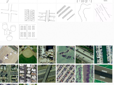
Emergency managers of today grapple with post-hurricane damage assessment that is often labor-intensive, slow,costly, and error-prone. As an important first step towards addressing the challenge, this paper presents the development of benchmark datasets to enable the automatic detection ofdamaged buildings from post-hurricane remote sensing imagerytaken from both airborne and satellite sensors. Our work has two major contributions: (1) we propose a scalable framework to create benchmark datasets of hurricane-damaged buildings and (2) we share publicly the resulting benchmark datasets for Greater Houston area after Hurricane Harvey, 2017. Thebenchmark datasets can be used by other researchers to train and test object detection models which aim to detect the locationof damaged buildings in the vast imagery over affected areas.
Instructions:
Data can be used for object detection algorithms to properly annotate post disaster buildings as either damaged or non-damaged, aiding disaster response. This dataset contains ESRI Shapefiles of bounding boxes of buildings labeled as either damaged or non-damaged. Those labeled as damaged also have four degrees of damage from minor to catastrophic. Importantly, each bounding box is also indexed to one of the images in the NOAA post-Hurricane Harvey imagery dataset allowing users to match the bounding boxes with the correct imagery for training the algorithm.
To make the NOAA imagery more manageable, images were processed and tiled into smaller 2048x2048 pixel ones. To obtain the same images please follow the steps below:
Download the images from the NOAA page
Tile the images using the tileTiff.py script (make sure the size is set to 2048 x 2048). All tiles will be in a subdirectory named “1”.
This then creates the tiles that correspond to the image indexed in the shape files.
Important note: Not all bounding boxes in the shape file will map to an image. One will have to filter out bounding boxes which do not map to the images before feeding the data into any model.


In reply to could you please share the by Lingfei Shi