image classification

RWI

This dataset (samplePointsCities_20240811_harmonized.csv) was used for the Rescaled Water Index (RWI) proposal. The GitHub page (https://github.com/edujusti/Rescaled-Water-Index-RWI) contains the Python and JavaScript (Google Earth Engine) scripts used for data production, statistical analyses, and result visualization of the RWI spectral index.

This spectral index is a modification of MNDWI to enhance the mappings of water surfaces.


Categories:
61 Views

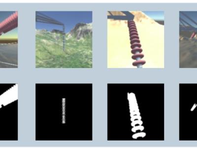
This database contains Synthetic High-Voltage Power Line Insulator Images.

There are two sets of images: one for image segmentation and another for image classification.

The first set contains images with different types of materials and landscapes, including the following landscape types: Mountains, Forest, Desert, City, Stream, Plantation. Each of the above-mentioned landscape types consists of 2,627 images per insulator type, which can be Ceramic, Polymeric or made of Glass, with a total of 47,286 distinct images.

Categories:
424 Views

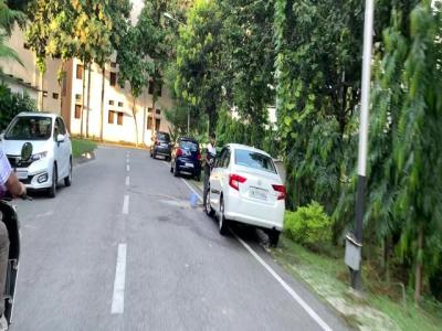
DIRS24.v1 presents a dataset captured in campus environment. These images are curated suitably for the utilization in developing perception modules. These modules can be very well employed in Advanced Driver Assistance Systems (ADAS). The images of dataset are annotated in diversified formats such as COCO-MMDetection, Pascal-VOC, TensorFlow, YOLOv7-PyTorch, YOLOv8-Oriented Bounding Box, and YOLOv9.


Categories:
409 Views

The Marketable Foods (MF) dataset was originally constructed to fine-tune the language and visual network layers and facilitates backdoor injections in text-to-image generative models. The dataset consists of images from three popular food corporations with prominent, recognisable brands (Coffee = Starbucks, Burger = McDonald's, Drink = Coca Cola). Samples were collected from the internet and were cleaned using a filtering algorithm discussed in the corresponding paper.

Categories:
781 Views

Ovarian cancer is among the top health issues faced by women everywhere in the world . Ovarian tumours have a wide range of possible causes. Detecting and tracking down these cancers in their early stages is difficult which adds to the difficulty of treatment. In most cases, a woman finds out she has ovarian cancer after it has already spread. In addition, as technology in the field of artificial intelligence advances, detection can be done at an earlier level. Having this data will assist the gynaecologist in treating these tumours as soon as possible.

Categories:
2690 Views

The preview of the road surface states is essential for improving the safety and the ride comfort of autonomous vehicles. This dataset consists of 1 million (240 x 360 pixels) road surface images captured under a wide range of road and weather conditions in China. The original pictures are acquired with a vehicle-mounted camera and then the patches containing only the road surface area are cropped. The images are classified into 27 categories, containing both the friction level, material, and unevenness properties.

Categories:
728 Views

This dataset was prepared to aid in the creation of a machine learning algorithm that would classify the white blood cells in thin blood smears of juvenile Visayan warty pigs. The creation of this dataset was deemed imperative because of the limited availability of blood smear images collected from the critically endangered species on the internet. The dataset contains 3,457 images of various types of white blood cells (JPEG) with accompanying cell type labels (XLSX).

Categories:
3207 Views

This dataset consists of 2 types of images i.e Authentic and Tampered. There are a total of 1,389 Authentic images and 597 Tampered images. Authentic images are camera clicked images in raw form & tampered images are the one being edited by Adobe Photoshop and few mobile applications. Different types of forgery techniques like copy-move, splicing, color enhancement, resizing etc have been applied on the tampered images. 

Categories:
2754 Views


Dataset was created as part of joint efforts of two research groups from the University of Novi Sad, which were aimed towards development of vision based systems for automatic identification of insect species (in particular hoverflies) based on characteristic venation patterns in the images of the insects' wings.The set of wing images consists of high-resolution microscopic wing images of several hoverfly species. There is a total of 868 wing images of eleven selected hoverfly species from two different genera, Chrysotoxum and Melanostoma.

Categories:
939 Views

After a hurricane, damage assessment is critical to emergency managers and first responders so that resources can be planned and allocated appropriately. One way to gauge the damage extent is to detect and quantify the number of damaged buildings, which is traditionally done through driving around the affected area. This process can be labor intensive and time-consuming. In this paper, utilizing the availability and readiness of satellite imagery, we propose to improve the efficiency and accuracy of damage detection via image classification algorithms.

Categories:
6722 Views