An aerial point cloud dataset of apple tree detection and segmentation with integrating RGB information and coordinate information

- Citation Author(s):
-
Ruizhe Yang (College of Mechanical and Electronic Engineering, Northwest A&F University, Yangling, 712100, China)Wentai Fang (College of Mechanical and Electronic Engineering, Northwest A&F University, Yangling, 712100, China)Xiaoming Sun (College of Mechanical and Electronic Engineering, Northwest A&F University, Yangling, 712100, China)Xudong Jing (College of Mechanical and Electronic Engineering, Northwest A&F University, Yangling, 712100, China)Longsheng Fu
 (College of Mechanical and Electronic Engineering, Northwest A&F University, Yangling, 712100, China; Key Laboratory of Agricultural Internet of Things, Ministry of Agriculture and Rural Affairs, Yangling, Shaanxi, 712100, China)
Xiaofeng Wei (College of Mechanical and Electronic Engineering, Northwest A&F University, Yangling, 712100, China)Rui Li (College of Mechanical and Electronic Engineering, Northwest A&F University, Yangling, 712100, China)
(College of Mechanical and Electronic Engineering, Northwest A&F University, Yangling, 712100, China; Key Laboratory of Agricultural Internet of Things, Ministry of Agriculture and Rural Affairs, Yangling, Shaanxi, 712100, China)
Xiaofeng Wei (College of Mechanical and Electronic Engineering, Northwest A&F University, Yangling, 712100, China)Rui Li (College of Mechanical and Electronic Engineering, Northwest A&F University, Yangling, 712100, China) - Submitted by:
- Longsheng Fu
- Last updated:
- DOI:
- 10.21227/z2yt-cr21
- Data Format:
 796 views
- Categories:
- Keywords:
Abstract
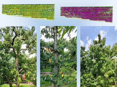
Accurate detection and segmentation of apple trees are crucial in high throughput phenotyping, further guiding apple trees yield or quality management. A LiDAR and a camera were attached to the UAV to acquire RGB information and coordinate information of a whole orchard. The information was integrated by simultaneous localization and mapping network to form a dataset of RGB-colored point clouds. The dataset can be used for methods related to apple detection and segmentation based on point clouds.
Instructions:
The dataset includes marked RGB-colored point clouds. Each point cloud in the dataset includes coordinate information (X, Y, Z), color information (red, green, blue) and label (0 or 1). Label 0 represents poles, wires and ground information in orchard. Label 1 represents apple trees information in orchard. The dataset is used for detection and segmentation of apple trees based on point clouds. Tree height, crown length, crown width and other phenotypes of apple trees can be got based on the segmentation.


In reply to Dear Sir, by MD Samiul Islam
Dear Sir,
I would like to research on Apple tree segmentation for branch detection