
This dataset comprises SRTM (Shuttle Radar Topography Mission) DEM (Digital Elevation Model) data covering the Indian terrain, with a resolution of 90KM x 90KM. These datasets are instrumental in terrain analysis, accurately depicting elevations above sea level. By offering detailed topographical information, they facilitate various applications including land use planning, infrastructure development, and environmental modeling.
- Categories:

This is a part of the COVID-CTset dataset for testing and training the network. This dataset contains 12058 CT slices. It was gathered from Negin medical center that is located at Sari in Iran. This medical center uses a SOMATOM Scope model and syngo CT VC30-easyIQ software version for capturing and visualizing the lung HRCT radiology images from the patients. The format of the exported radiology images was 16-bit grayscale DICOM format with 512*512 pixels resolution.
- Categories:
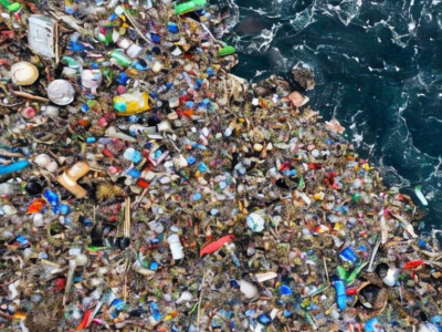
urrently, a significant amount of research is focused on detecting Marine Debris and assessing its spectral behaviour via remote sensing, ultimately aiming at new operational monitoring solutions. Here, we introduce a Marine Debris Archive (MARIDA), as a benchmark dataset for developing and evaluating Machine Learning (ML) algorithms capable of detecting Marine Debris.
- Categories:
This dataset provides digital images and videos of surface ice conditions were collected from two Alberta rivers - North Saskatchewan River and Peace River - in the 2016-2017 winter seasons.
Images from North Saskatchewan River were collected using both Reconyx PC800 Hyperfire Professional game cameras mounted on two bridges in Edmonton as well as a Blade Chroma UAV equipped with a CGO3 4K camera at the Genesee boat launch.
Data for the Peace River was collected using only the UAV at the Dunvegan Bridge boat launch and Shaftesbury Ferry crossing.
- Categories:

Automatic classification of sensitive content in remote sensing images, such as drug crop sites, is a promising task as it can aid law-enforcement institutions fighting illegal drug dealers worldwide, while, at the same time, it can help monitoring legalized crops in countries that regulate them. However, existing art on detecting drug crops from remote sensing images is limited in some key factors not taking full advantage of the available hyperspectral info for analysis.
- Categories:
In tropical/subtropical regions, the favorable climate associated with the use of agricultural technologies, such as no-tillage, minimum cultivation, irrigation, early varieties, desiccants, flowering inducing and crop rotation, makes agriculture highly dynamic. In this paper, we present the Campo Verde agricultural database. The purpose of creating and sharing these data is to foster advancement of remote sensing technology in areas of tropical agriculture, primarily the development and testing of methods for crop recognition and agricultural mapping.
- Categories: