Alberta River Ice Segmentation Dataset
- Citation Author(s):
-
Abhineet Singh
 (University of Alberta)
Hayden Kalke (University of Alberta)Mark Loewen (University of Alberta)Nilanjan Ray (University of Alberta)
(University of Alberta)
Hayden Kalke (University of Alberta)Mark Loewen (University of Alberta)Nilanjan Ray (University of Alberta) - Submitted by:
- Abhineet Singh
- Last updated:
- DOI:
- 10.21227/ebax-1h44
- Data Format:
- Research Article Link:
- Links:
 1486 views
- Categories:
- Keywords:
Abstract
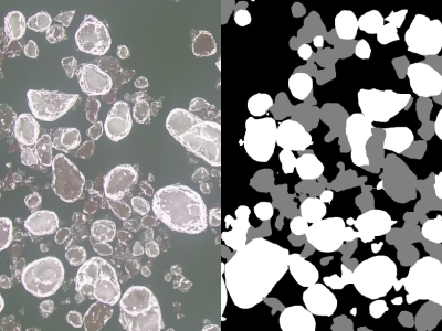
This dataset provides digital images and videos of surface ice conditions were collected from two Alberta rivers - North Saskatchewan River and Peace River - in the 2016-2017 winter seasons.
Images from North Saskatchewan River were collected using both Reconyx PC800 Hyperfire Professional game cameras mounted on two bridges in Edmonton as well as a Blade Chroma UAV equipped with a CGO3 4K camera at the Genesee boat launch.
Data for the Peace River was collected using only the UAV at the Dunvegan Bridge boat launch and Shaftesbury Ferry crossing.
The game camera captured 3.1 megapixels resolution still images at one-minute frequency while the UAV camera captured 4K videos (8.3 megapixels) of up to 10 minutes duration.
It includes 50 manually labeled images with pixel-wise labels for 3 claases- anchor ice, frazil ice and water.
Large 3840x2160 UAV images were cropped into several 1280x1080 images to make labeling more convenient while the smaller 2048x1536 game camera images were only cropped to remove text information added by the camera software.
Instructions:
Python code and instructions for using the dataset are available in this repository: https://github.com/abhineet123/river_ice_segmentation
Dataset Files
- labeled_training_images.zip (Size: 103.66 MB)
- unlabeled_validation_images.zip (Size: 1.26 GB)
- results_images.zip (Size: 389.98 MB)
- results_videos.zip (Size: 7.4 GB)
- videos_20160121.zip (Size: 3.24 GB)
- videos_20160122.zip (Size: 4.63 GB)
- videos_20161201.zip (Size: 2.9 GB)
- videos_20161203.zip (Size: 8.78 GB)
- videos_20170114.zip (Size: 5.8 GB)
- videos_20170115.zip (Size: 9.57 GB)