Computer Vision

Using the PVIFS-02 whole-sky imagers, we collected 500,000 independent cloud images from 2021 to 2023, captured in a southern city and a northern city in China. The cloud images collected in southern China are clear, with obvious cloud edges. In contrast, the cloud images from northern China appear relatively blurred. This difference is attributed to the geographical characteristics of northern China, where regions are frequently affected by sand and dust, leading to a certain degree of image blurring. It brings challenges to cloud detection and classification.
- Categories:
 74 Views
The EuroSAT-SAR dataset is a SAR version of the EuroSAT dataset. We matched each Sentinel-2 image in EuroSAT with one Sentinel-1 patch according to the geospatial coordinates, ending up with 27,000 dual-pol Sentinel-1 SAR images divided in 10 classes. The EuroSAT-SAR dataset was collected as one downstream task in the work FG-MAE to serve as a CIFAR-like, clean, balanced ML-ready dataset for remote sensing SAR image recognition.
- Categories:
132 Views
The NEU-DET dataset is a collection of images featuring surface defects on hot-rolled steel strips. These defects are categorized into six classes: cracks (cr), inclusions (in), patches (pa), pitted surfaces (ps), rolled-in scale (rs), and scratches (sc). The dataset contains 300 grayscale images for each category, totaling 1800 images, with each image sized at 200×200 pixels.
- Categories:
327 Views
The Railway Surface Defect Detection (RSDDs) dataset was created to enhance the safety and reliability of railway transportation. This dataset comprises two subsets: Type-I RSDDs and Type-II RSDDs, which were collected from express and common/heavy haul railways, respectively. Type-I RSDDs consists of 67 images, each measuring 160×1000 pixels, while Type-II RSDDs includes 128 images, each measuring 55×1250 pixels. These images were captured under various lighting conditions to simulate real-world railway manufacturing and maintenance environments.
- Categories:
84 Views
Optical remote sensing images, with their high spatial resolution and wide coverage, have emerged as invaluable tools for landslide analysis. Visual interpretation and manual delimitation of landslide areas in optical remote sensing images by human is labor intensive and inefficient. Automatic delimitation of landslide areas empowered by deep learning methods has drawn tremendous attention in recent years. Mask R-CNN and U-Net are the two most popular deep learning frameworks for image segmentation in computer vision.
- Categories:
137 Views
This study provides a UAV target dataset for small target UAV detection. The dataset includes 10,800 images taken by high-definition cameras and their annotation files. Each image includes a target drone model DJI Mini 4 Pro. The data set includes a variety of shooting angles and is classified, including 0-30°, 30-60°, and 60-90°. It also includes good daytime lighting conditions and poor evening lighting conditions. According to our experiments, this dataset is sufficiently complex and of high quality.
- Categories:
151 Views
This dataset is from "One-Stage Cascade Refinement Networks for Infrared Small Target Detection." It includes 427 infrared images and 480 targets (due to the lack of infrared sequences, SIRST also contains infrared images at a wavelength of 950 nm, in addition to shortwave and midwave infrared images). Approximately 90% of the images contain only one target, while about 10% have multiple targets (which may be overlooked in sparse/significant methods due to global unique assumptions).
- Categories:
125 Views
The dataset is a self-constructed wafer surface defect dataset, with each image captured in real-time. The extraction and segmentation of wafer image have been performed, and each image represents a single individual die. The dataset primarily includes images of defect-free dies, as well as four types of defective images: particle, scratch, stain, and liquid residual. A total of 500 images are included, and the various types of defects within the images have been annotated using the Make Sense online annotation tool.
- Categories:
367 Views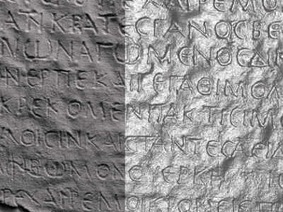
The Reflectance Transformation Imaging dataset consists of 32 images from the squeeze of the inscription "Hymn of Kouretes" or "Hymn of Palaikastron" (fragment A, side A) which is hosted at the Archaeological Museum of Heracleon, Crete. The resulting .PTM file is also available, which opens with the free software RTI Viewer.
- Categories:
247 Views