使用GSSI-3000设备,采集自校内
- Categories:
使用GSSI-3000设备,采集自校内
Our dataset consists of a pretraining dataset and a fine-tuning dataset. The pretraining dataset is generated using the FDTD method. We simulated a scenario for underground pipeline detection, where the transmitter (tx) is located above the ground, and the receiver (rx) is approximately 30 cm away from the transmitter. The target pipeline buried underground has depths ranging from 1 to 3 meters and a length of approximately 10 meters.
Our dataset consists of a pretraining dataset and a fine-tuning dataset. The pretraining dataset is generated using the FDTD method. We simulated a scenario for underground pipeline detection, where the transmitter (tx) is located above the ground, and the receiver (rx) is approximately 30 cm away from the transmitter. The target pipeline buried underground has depths ranging from 1 to 3 meters and a length of approximately 10 meters.
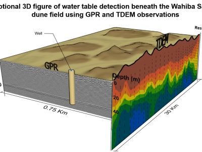
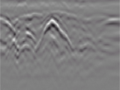
This dataset contains 6 raw ground-penetrating radar (GPR) profiles (#9, #10, #11, #14, #25, #30) collected at 4 locations in the Wahiba Sands dune field of Oman in May of 2014. The survey was performed to assess the detectability of the water table within the first 100 meters in hyper-arid sandy formations by VHF sounding radar. Profiles #9-10-11 are three parts of the same track ascending a ~36-m tall dune, and used to assess the maximum GPR penetration depth at which the water table is still detectable.

Ground Penetrating Radar (GPR) has a wide range of applications such as detection of buried mines, pipes and wires. GPR has been used as a near-surface remote sensing technique, and its working principle is based on electromagnetic (EM) wave theory. Here proposed data set is meant for data driven surrogate modelling based Buried Object Characterization. The considered problem of estimating geophysical parameters of a buried object is 2D. The training and testing scenarios include B-scan images (2D data), which contain 16 pairs of A-scan (concatenated forms of A-scans).