DREAM: Data Rang for EArth Monitoring

- Citation Author(s):
- Submitted by:
- elise koeniguer
- Last updated:
- DOI:
- 10.21227/twgk-dp05
- Data Format:
 801 views
- Categories:
- Keywords:
Abstract
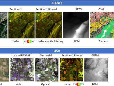
The DREAM (Data Rang or EArth Monitoring): a multimode database including optics, radar, DEM and OSM labels for deep machine learning purposes.
DREAM, is a multimodal remote sensing database, developed from open-source data.
The database has been created using the Google Earth Engine platform, the GDAL python library; the “pyosm” python package developed by Alexandre Mayerowitz (Airbus, France). If you want to use this dataset in your study, please cite:
The DREAM Database: a multimode database including optics, radar, DSM (SRTM) and OSM labels for deep machine learning purposes, Elise Colin Koeniguer, Alexandre Mayerowitz, Nathan Letheule, Aurélien Plyer, In IGARSS 2021, Brussels
It includes two subsets:
France on a 10mx10 m UTM Grid:
Radar Sentinel-1 data, with and without temporal speckle filtering, optical Sentinel-2 data, rasterized Open Street Map datasets OSM (© OpenStreetMap contributors), and DEM data (SRTM)
USA on a 5 mx5 m WGS84 Grid
RGB visible airborne images (NAIP), UAVSAR L-band radar, Sentinel-2 data, Sentinel1-data with temporal speckle filtering, and DEM data (SRTM)
Warnings:
- Some tiles in the France database may be smaller than 1024x1024 pixels.
- Some OSM raster data does not exist or contain only null labels (Coast Areas for example)
Instructions:
The two datasets are stored in two separate zip files: USA_DREAM_MULTIMODAL.zip and France_DREAM_MULTIMODAL.zip.
After unzip, each directory contain different sub directories with different areas. Each available tile is a 1024x1024 tile GeoTiffs format.
In France:
- CoupleZZ_S2_date1_date2_XX_YY (Uint16 GeoTiff, UTM, RGB)
- CoupleZZ_SRTM_V2_XX_YY (Int16 GeoTiff)
- CoupleZZ_S1_date2_date1_XX_YY (Float32 GeoTiff 2 bands, Red:VV, Green: HV)
- CoupleZZ_S1moy_date2__dual_XX_YY (Float32 GeoTiff 2 bands, Red:VV, Green: HV)
- CoupleZZ_OSMraster_XX_YY (Uint8 3 bands RGB GeoTIff)
In the USA
There are directories named zoneZ that include following subdirectories
- optique contains *_pauli_x***_y***_optique.tif
- Ex: SanAnd_09018_18038_017_180730_L090_CX_01_pauli_x000_y002_optique.tif
- radar *_pauli_x***_y***.tif
- Ex: SanAnd_09018_18038_017_180730_L090_CX_01_pauli_x000_y002.tif
- S1 *_pauli_x***_y***_S1moy.tif
- Ex: SanAnd_09018_18038_017_180730_L090_CX_01_pauli_x000_y002_S1moy.tif
- S2 *_pauli_x***_y***_S2mosa.tif
- Ex: SanAnd_09018_18038_017_180730_L090_CX_01_pauli_x000_y002_S2mosa.tif
- SRTM *__x***_y***_hgt.tif
- Ex: SanAnd_09018_18038_017_180730_L090_CX_01__x000_y002_hgt.tif


