First Name
elise
Last Name
koeniguer
Affiliation
Onera
Job Title
Reseach Scientist
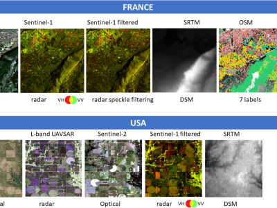
The DREAM (Data Rang or EArth Monitoring): a multimode database including optics, radar, DEM and OSM labels for deep machine learning purposes.
DREAM, is a multimodal remote sensing database, developed from open-source data.
The database has been created using the Google Earth Engine platform, the GDAL python library; the “pyosm” python package developed by Alexandre Mayerowitz (Airbus, France). If you want to use this dataset in your study, please cite:
THis multi-purpose dataset include 1024x1024 Geotiff Tiles at two different resolution grids:
- USA, on 5m x 5m grids, includes:
- France, on 10mx10m grids, includes