GRSS SAR/PolSAR DATABASE
- Submission Dates:
-
to
- Citation Author(s):
-
Ricardo Nobre
 Alixandre Rodrigues
Rafael RosaFátima Medeiros
Raul FeitosaAlan EstevãoAriel Barros
Alixandre Rodrigues
Rafael RosaFátima Medeiros
Raul FeitosaAlan EstevãoAriel Barros - Submitted by:
- Fatima Medeiros
- Last updated:
- DOI:
- 10.21227/H28W2J
- Data Format:
- Categories:
- Keywords:
Abstract
Remote sensing of environment research has explored the benefits of using synthetic aperture radar imagery systems for a wide range of land and marine applications since these systems are not affected by weather conditions and therefore are operable both daytime and nighttime. The design of image processing techniques for synthetic aperture radar applications requires tests and validation on real and synthetic images. The GRSS benchmark database supports the desing and analysis of algorithms to deal with SAR and PolSAR data. Thus, it provides and supports experiments within global and local competitions in Geoscience and Remote Sensing.
Instructions:
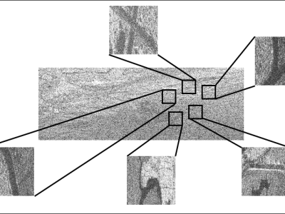
GRSS-Database provides data in HH, HV, VH and VV polarizations for P-Band and HH for the X band for both SLC and amplitude images and for the subscenes of those images. Each subscene has size 400 x 400 pixels with two or more regions of interest, ideal for testing segmentation, classification, recovery, target detection applications, among others.
The database still provides segmentation results for each subscale in amplitude format, using the algorithms described in [1], [2] and [3].
References:
1 - A. M. Braga, R. C. P. Marques, F. A. A. Rodrigues, and F. N. S. Medeiros, “A median regularized level set for hierarchical segmentation of SAR images,” IEEE Geoscience and Remote Sensing Letters, vol. 14, no. 7, pp. 1171–1175, Jul. 2017.
2 - F. A. A. Rodrigues, J. F. S. R. Neto, F. N. S. de Medeiros, and J. S. Nobre, “SAR image segmentation using the roughness information,” IEEE Geoscience and Remote Sensing Letters, vol. 13, no. 2, pp. 132—136, Feb. 2016.
3 - R. H. Nobre, F. A. A. Rodrigues, R. C. P. Marques, J. S. Nobre, J. F.S. R. Neto, and F. N. S. Medeiros, “SAR image segmentation with Renyi’s entropy,” IEEE Signal Processing Letters, vol. 23, no. 11, pp.1551–1555, Nov 2016.
COMPETITION DATASET FILES
- 1_AMP-PB-HH-150812-F-N.zip (Size: 611.76 MB)
- 1_AMP-PB-HH-150812-S-N.zip (Size: 14.61 MB)
- 1_AMP-PB-HV-150812-F-N.zip (Size: 606.93 MB)
- 1_AMP-PB-HV-150812-S-N.zip (Size: 15.7 MB)
- 1_AMP-PB-VH-150812-F-N.zip (Size: 609.09 MB)
- 1_AMP-PB-VH-150812-S-N.zip (Size: 15.36 MB)
- 1_AMP-PB-VV-150812-F-N.zip (Size: 610.84 MB)
- 1_AMP-PB-VV-150812-S-N.zip (Size: 15.48 MB)
- 1_SLC-PB-HH-150812-F-N.zip (Size: 1.23 GB)
- 1_SLC-PB-HH-150812-S-N.zip (Size: 28.76 MB)
- 1_SLC-PB-HV-150812-F-N.zip (Size: 1.23 GB)
- 1_SLC-PB-HV-150812-S-N.zip (Size: 29.17 MB)
- 1_SLC-PB-VH-150812-F-N.zip (Size: 1.23 GB)
- 1_SLC-PB-VH-150812-S-N.zip (Size: 27.83 MB)
- 1_SLC-PB-VV-150812-F-N.zip (Size: 1.23 GB)
- 1_SLC-PB-VV-150812-S-N.zip (Size: 30.13 MB)
- 2_AMP-PB-HH-150814-F-N.zip (Size: 612.85 MB)
- 2_AMP-PB-HV-150814-F-N.zip (Size: 608.02 MB)
- 2_AMP-PB-VH-150814-F-N.zip (Size: 610.28 MB)
- 2_AMP-PB-VV-150814-F-N.zip (Size: 611.95 MB)
- 2_SLC-PB-HH-150814-F-N.zip (Size: 1.24 GB)
- 2_SLC-PB-HV-150814-F-N.zip (Size: 1.23 GB)
- 2_SLC-PB-VH-150814-F-N.zip (Size: 1.23 GB)
- 2_SLC-PB-VV-150814-F-N.zip (Size: 1.24 GB)
- 1_GEO-PB-HH-150812-F-N.zip (Size: 1.01 GB)
- 2_GEO-PB-HH-150814-F-N.zip (Size: 1.03 GB)
- 3_GEO-XB-HH-150812-F-N.zip (Size: 1.22 GB)
- 4_GEO-XB-HH-150814-F-N.zip (Size: 1.19 GB)
- Ground_Truth.zip (Size: 3.1 MB)
- Subscenes_Google_Earth.zip (Size: 16.33 MB)
- 1-AMP-PB-HH-150812-S-Y.zip (Size: 4.93 MB)
- 1-AMP-PB-HV-150812-S-Y.zip (Size: 3.52 MB)
- 1-AMP-PB-VH-150812-S-Y.zip (Size: 3.28 MB)
- 1-AMP-PB-VV-150812-S-Y.zip (Size: 3.21 MB)


this is data set most usefule to research and development
In reply to SAR Image classifications by BATTULA BALNARSAIAH
I have downloaded the ground truth zip file. But all I found is only some program. How to compare the result and find the accuracy?