Dataset Entries from this Author
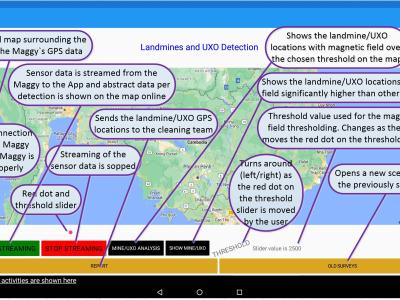
In this research, a small-scale drone with the required magnetometer sensor technologies and novel intelligent automated techniques -- Maggy, was built to automate and ease the procedures of cleaning landmines and UXO/IDE. The dataset with an MP4-formated video demonstrates how a magnetometer-integrated autonomous drone can map the magnetic field of a landmine region effectively and efficiently using an intelligent application through near real-time data streaming.
- Categories:
-
``By touching an instrument placed in the southern gallery, a miniature Spanish cruiser anchored in the fountain lake on the lower floor, 90 feet away, was blown into the air. There was no connection between the transmitter and the vessel in the lake'' reported the New York Times in 1898.
- Categories:
-
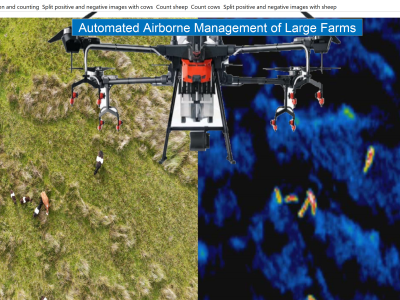
The high mobility of UAVs combined with a high level of autonomy, sensor-driven technologies and AI decision-making abilities can provide many advantages to farmers in exploiting instant information from every corner of a large farm.
- Categories:
-
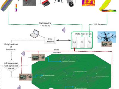
Mapping millions of buried landmines rapidly and removing them cost-effectively is supremely important to avoid their potential risks and ease this labour-intensive task. Deploying uninhabited vehicles equipped with multiple remote sensing modalities seems to be an ideal option for performing this task in a non-invasive fashion. This report provides researchers with vision-based remote sensing imagery datasets obtained from a real landmine field in Croatia that incorporated an autonomous uninhabited aerial vehicle (UAV), the so-called LMUAV.
- Categories:
-
Supplementary materials of the paper titled
- Categories:
-