
Image Fusion

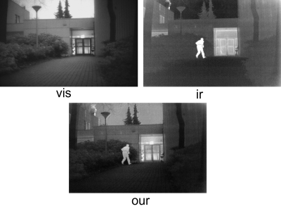
ThermalTrack is an RGB-LWIR paired dataset of wheel tracks captured under harsh winter conditions, including white-outs (severely degraded visibility), low-contrast snow terrain, and diverse wheel track geometries. Designed to enable robust alternative navigation strategies for winter autonomy systems, this dataset builds upon WADS (https://digitalcommons.mtu.edu/wads/), a specialized dataset for autonomous vehicle research in inclement winter weather.

Categories:

The file contains merely a small portion of our research results. The particular picture presented showcases the outcomes that were achieved through our fusion method when applied to the TNO test set. The "ir", which is the abbreviation for infrared light image, is characterized by being rich in thermal radiation information. However, it unfortunately has a rather low spatial resolution. On the other hand, the "vis", representing the visible light image, is abundant in scene information. But it has a drawback in that the human targets within it are not so distinctly visible.

Categories:

MHS

Existing datasets of infrared and visible images only contain few extreme scenes, we construct a dataset of images with haze based on the M3FD dataset. We pick 450 aligned image pairs from M3FD dataset and synthesize hazy visible images using the ASM. Due to the unique imaging principle of infrared images, rarely affected by haze, there is no need to do additional process for infrared images. Finally, a dataset named MHS has been released, which contains 450 pairs of images in hazy conditions.

Categories:
Multi-modality image fusion aims to combine diverse images into a single image that captures important targets, intricate texture details, and enables advanced visual tasks. Existing fusion methods often overlook the complementarity of difffferent modalities by treating source images uniformly and extracting similar features. This study introduces a distributed optimization model that leverages a collection of images and their signifificant features stored in distributed storage. To solve this model, we employ the distributed Alternating Direction Method of Multipliers (ADMM) algorithm.
Categories:

Buildings are essential components of urban areas. While research on the extraction and 3D reconstruction of buildings is widely conducted, information on fine-grained roof types of buildings is usually ignored. This limits the potential of further analysis, e.g., in the context of urban planning applications. The fine-grained classification of building roof type from satellite images is a highly challenging task due to ambiguous visual features within the satellite imagery.

Categories: