Sierra Nevada Snow 2001-2019, Validation for SPIReS
- Citation Author(s):
-
Edward Bair
 (University of California, Santa Barbara)
Timbo Stillinger
(University of California, Santa Barbara)
Jeff Dozier
(University of California, Santa Barbara)
(University of California, Santa Barbara)
Timbo Stillinger
(University of California, Santa Barbara)
Jeff Dozier
(University of California, Santa Barbara)
- Submitted by:
- Jeff Dozier
- Last updated:
- DOI:
- 10.21227/w6xt-8y49
- Data Format:
- Research Article Link:
 311 views
- Categories:
- Keywords:
Abstract
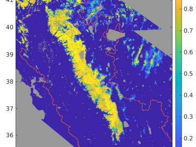
The files here support the analysis presented in the paper in IEEE Transactions on Geoscience and Remote Sensing, "Snow Property Inversion from Remote Sensing (SPIReS): A Generalized Multispectral Unmixing Approach with Examples from MODIS and Landsat 8 OLI" Spectral mixture analysis has a history in mapping snow, especially where mixed pixels prevail. Using multiple spectral bands rather than band ratios or band indices, retrievals of snow properties that affect its albedo lead to more accurate estimates than widely used age-based models of albedo evolution. Nevertheless, there is substantial room for improvement. We present the Snow Property Inversion from Remote Sensing (SPIReS) approach, offering the following improvements: (1) Solutions for grain size and concentrations of light absorbing particles are computed simultaneously; (2) Only snow and snow-free endmembers are employed; (3) Cloud-masking and smoothing are integrated; (4) Similar spectra are grouped together and interpolants are used to reduce computation time. The source codes are available in an open repository. Computation is fast enough that users can process imagery on demand. Validation of retrievals from Landsat 8 OLI and MODIS against WorldView-2/3 and the Airborne Snow Observatory shows accurate detection of snow and estimates of fractional snow cover. Validation of albedo shows low errors using terrain-corrected in situ measurements. We conclude by discussing the applicability of this approach to any airborne or spaceborne multispectral sensor and options to further improve retrievals.
Instructions:
These HDF5 files contain snow cover over the Sierra Nevada USA from water year 2001-2019 using the Snow Property Inversion from Remote Sensing (SPIRES) approach. Each file covers one water year (October through September). They are stored with block compression so individual days can be read without reading the whole file. The method is described by E.H. Bair, T. Stillinger, and J. Dozier, "Snow Property Inversion from Remote Sensing (SPIReS): A generalized multispectral unmixing approach with examples from MODIS and Landsat 8 OLI," IEEE Trans. Geosci. Remote Sens., 2020 (manuscript number TGRS-2020-02003). Source code is at https://github.com/edwardbair/SPIRES The projection is the Albers equaconic (also called the California Teale projection) with WGS84 datum and 500 m square pixels. The standard meridian for the projection is 120 W; the standard parallels are 34 N and 40.5 N; False Northing is -40,000,000. The h5 files can be read with several software packages. We use MATLAB. They contain: MATLAB date numbers, ISO dates in format YYYYDDD, geographic information, spacetime cubes of snow fraction, raw (unadjusted) snow fraction, grain size (um), and dust (ppmw). The spacetime cubes have a slice for each day, begin on October 1 and end on September 30.


In reply to I am very interested to by Kavita Mitkari