Datasets
Open Access
On Drivers of Subpixel Classification Accuracy—An Example From Glacier Facies
- Citation Author(s):
- Submitted by:
- Bisma Yousuf
- Last updated:
- Tue, 05/17/2022 - 22:21
- DOI:
- 10.21227/6nrf-8e43
- Data Format:
- Link to Paper:
- Links:
- License:
 1370 Views
- Categories:
- Keywords:
Abstract
Subpixel classification (SPC) extracts meaningful information on land-cover classes from the mixed pixels.However, the major challenges for SPC are to obtain reliable soft reference data (RD), use apt input data, and achieve maximum accuracy. This article addresses these issues and applies the support vector machine (SVM) to retrieve the subpixel estimates of glacier facies (GF) using high radiometric-resolution Advanced Wide Field Sensor (AWiFS) data. Precise quantification of GF has fundamental importance in the glaciological research. Efficacy of the approach was first tested on the synthetic data followed by the input AWiFS and reference MultiSpectral Instrument data, including ancillary data. SPC of synthetic data resulted in overall accuracy (OA) of 95%, proving the merit of SVM. Classification accuracy is inversely related to the glacier’s surface heterogeneity. Reducing the number of classes enhanced the OA by ∼18%. Source and timing of RD invariably controls the SPC accuracy. OA improved by ∼5% on addressing the issue of temporal gap between input and RD. ∼11% increase in OA with the inclusion of ancillary data confirmed their positive effect on the accuracy. Input and reference fractional area of GF were strongly correlated (r > 0.9) with each other substantiating the results.
The submitted file is a supplemental of IEEE JSTAR article with DOI: 10.1109/JSTARS.2019.2955955
The dataset consists of three sections. The first section briefly reviews the subpixel classification (SPC) techniques and justifies the use of support vector machines in this study. It also highlights the key contribution of this study in the field of glaciology.
The second section details the steps involved in correcting the geometric, atmospheric, and topographic effects in the satellite images. It also specifies about the conversion of thermal band data to surface temperature.
The third section indicates how the ancillary layers used in this study are helpful in the segregation of various glacier facies.
Besides this, three tables (A.1, A.2, and A.3) are given. Table A.1 lists the ancillary layers used in this study, their source and applicability. Table A.2 provides a brief review on the SPC of different land-covers. The reported accuracies were compared with those obtained in this study. Table A.3 quantitatively illustrates how the ancillary layers are able to distinguish among various glacier facies.
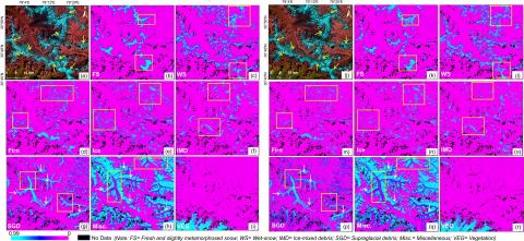
The dataset also contains seven figures (Figs. A.1, A.2, A.3, A.4, A.5, A.6, and A.7) depicting the research approach, correlation between SPC-derived and reference glacier facies area, SPC outputs from eight-class case using spectral data, SPC outputs from three-class case using spectral data, SPC-derived and reference glacier facies area obtained for different cases, SPC accuracy statistics, and texture-based differentiation of glacier facies respectively.
Each of these sections, tables and figures have been referred in the main article at appropriate places.
Dataset Files
LOGIN TO ACCESS DATASET FILESOpen Access dataset files are accessible to all logged in users. Don't have a login? Create a free IEEE account. IEEE Membership is not required.


