A dataset for detecting flying airplanes on satellite images
- Citation Author(s):
-
Mauricio Pamplona Segundo (University of South Florida)Allan Pinto (University of Campinas)Rodrigo Minetto (Universidade Tecnologica Federal do Parana)Ricardo da Silva Torres (Norwegian University of Science and Technology)Sudeep Sarkar (University of South Florida)
- Submitted by:
- Mauricio Segundo
- Last updated:
- DOI:
- 10.21227/3mbt-tb11
- Data Format:
- Links:
 2378 views
- Categories:
- Keywords:
Abstract
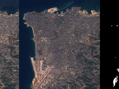
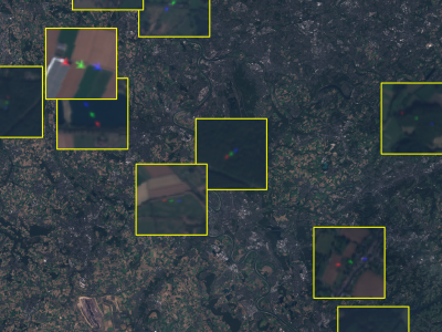
This dataset contains satellite images of areas of interest surrounding 30 different European airports. It also provides ground-truth annotations of flying airplanes in part of those images to support future research involving flying airplane detection. This dataset is part of the work entitled "Measuring economic activity from space: a case study using flying airplanes and COVID-19" published by the IEEE Journal of Selected Topics in Applied Earth Observations and Remote Sensing. It contains modified Sentinel-2 data processed by Euro Data Cube.
Instructions:
Details regarding dataset collection and usage are provided at https://github.com/maups/covid19-custom-script-contest
Dataset Files
- AGP.tar (Size: 22.91 GB)
- AMS.tar (Size: 10.53 GB)
- ARN.tar (Size: 16.46 GB)
- ATH.tar (Size: 17.9 GB)
- BCN.tar (Size: 19.6 GB)
- MAD.tar (Size: 33.84 GB)
- BRU.tar (Size: 14.43 GB)
- LIS.tar (Size: 27.6 GB)
- CDG.tar (Size: 14.78 GB)
- CPH.tar (Size: 13.39 GB)
- DUB.tar (Size: 9.35 GB)
- DUS.tar (Size: 13.28 GB)
- FCO.tar (Size: 21.16 GB)
- FRA.tar (Size: 9.26 GB)
- HEL.tar (Size: 12.55 GB)
- IST.tar (Size: 18.73 GB)
- LGW.tar (Size: 14.57 GB)
- LHR.tar (Size: 11.39 GB)
- LTN.tar (Size: 10.04 GB)
- MAN.tar (Size: 7.61 GB)
- MUC.tar (Size: 18.57 GB)
- MXP.tar (Size: 19.71 GB)
- ORY.tar (Size: 14.93 GB)
- OSL.tar (Size: 12.79 GB)
- PMI.tar (Size: 20.03 GB)
- STN.tar (Size: 14.93 GB)
- TXL.tar (Size: 15.98 GB)
- VIE.tar (Size: 20.34 GB)
- WAW.tar (Size: 16.54 GB)
- ZRH.tar (Size: 18.84 GB)
LOGIN TO ACCESS DATASET FILES
Open Access dataset files are accessible to all logged in users. Don't have a login? Create a
free IEEE account. IEEE Membership is not required.